-

Malawi: Floods - 7 day cumulative rainfall (as of 15 Jan 2015)
Map shows the cumulative rainfall total in millimetres (mm) during the seven day period 8-15 Jan 2015 (03:00 UTC) across Malawi. Figures are estimates from satellite... -
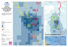
Vanuatu: Cyclone PAM - Accumulated Rainfall - 24 Hour Total (mm) (as of 14 Ma...
Map shows the 24 hourly accumulated rainfall total, the storm track of Cyclone Pam and its strength at specific times and locations. -

Vanuatu: Cyclone PAM - Accumulated Rainfall - 3 Hour Totals (mm) (as of 14 Ma...
Map shows selected 3 hourly accumulated rainfall totals at selected times and the storm track / intensity of Cyclone Pam. Note: This does not show the total rainfall - please... -
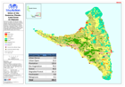
Union of the Comoros: Floods - Land Cover on Grande Comore
Land cover on Grande Comore. Showing affected villages. The data shown on this map were not created for the purposes of disaster response, and therefore should only be used as... -
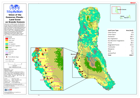
Union of the Comoros: Floods - Land Cover on Moheli
Land cover on Moheli. Showing affected villages. The data shown on this map were not created for the purposes of disaster response, and therefore should only be used as an... -
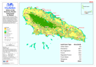
Union of the Comoros: Floods - Land Cover on Anjouan
Land cover on Anjouan. Showing affected villages. The data shown on this map were not created for the purposes of disaster response, and therefore should only be used as an...