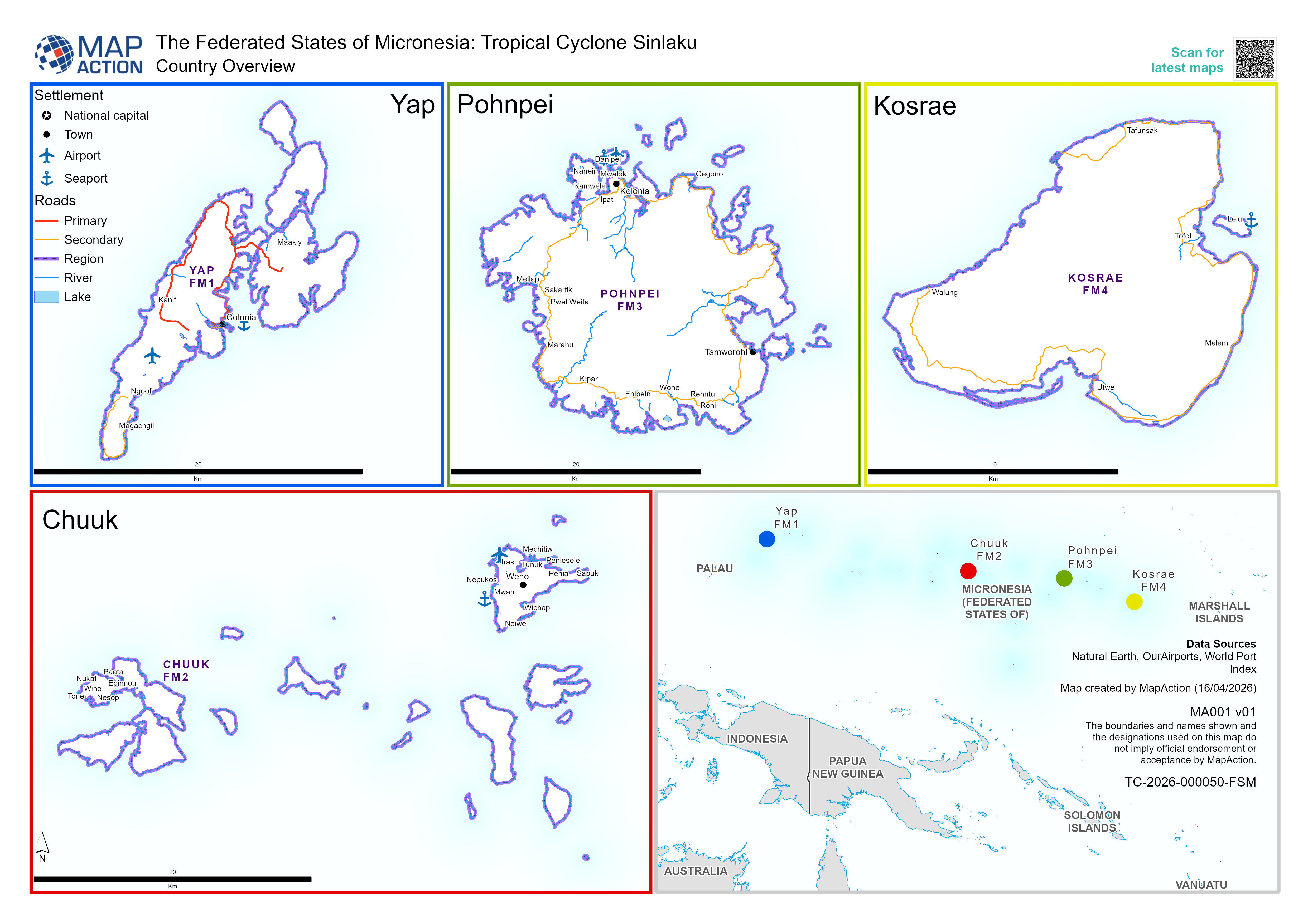
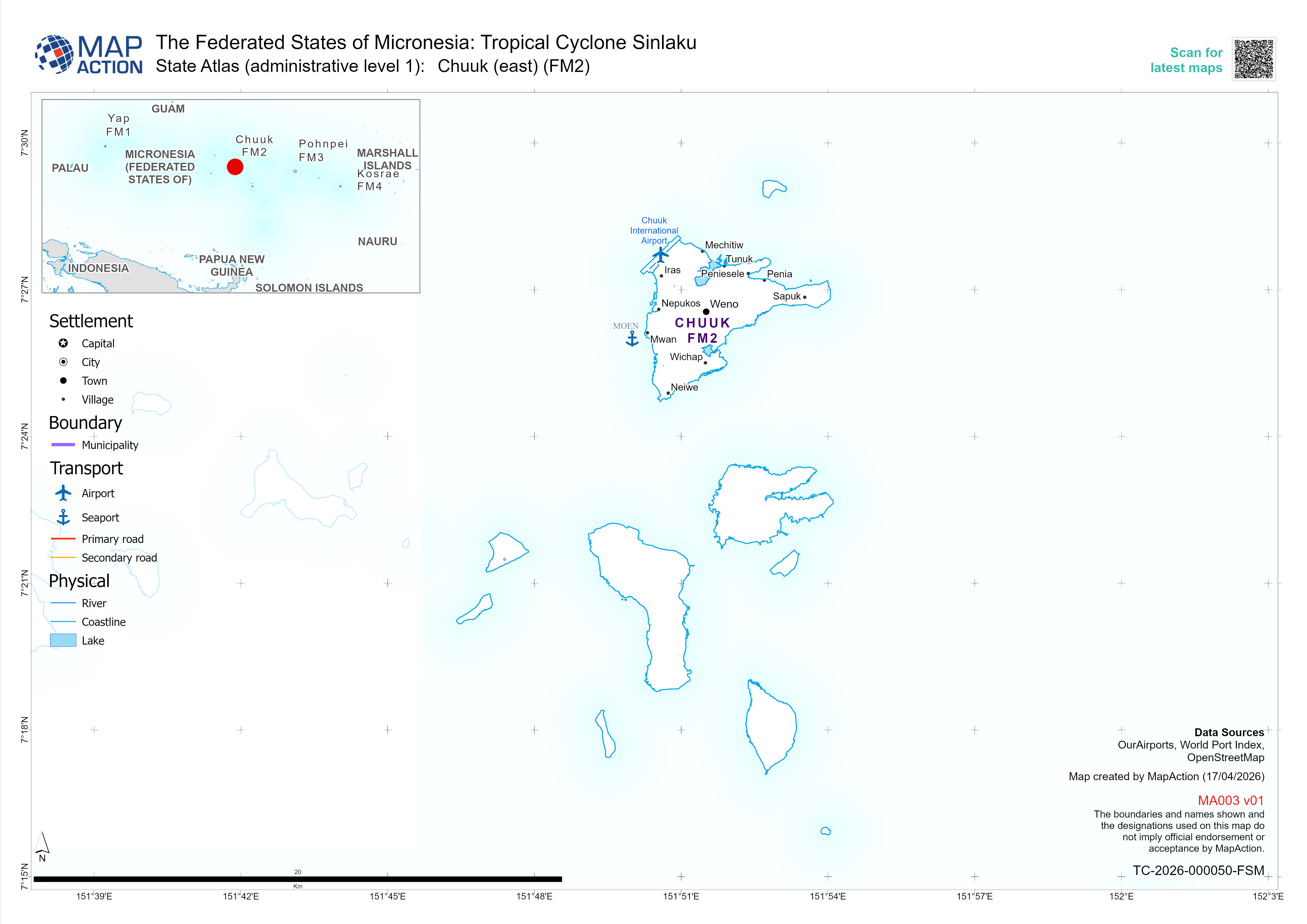
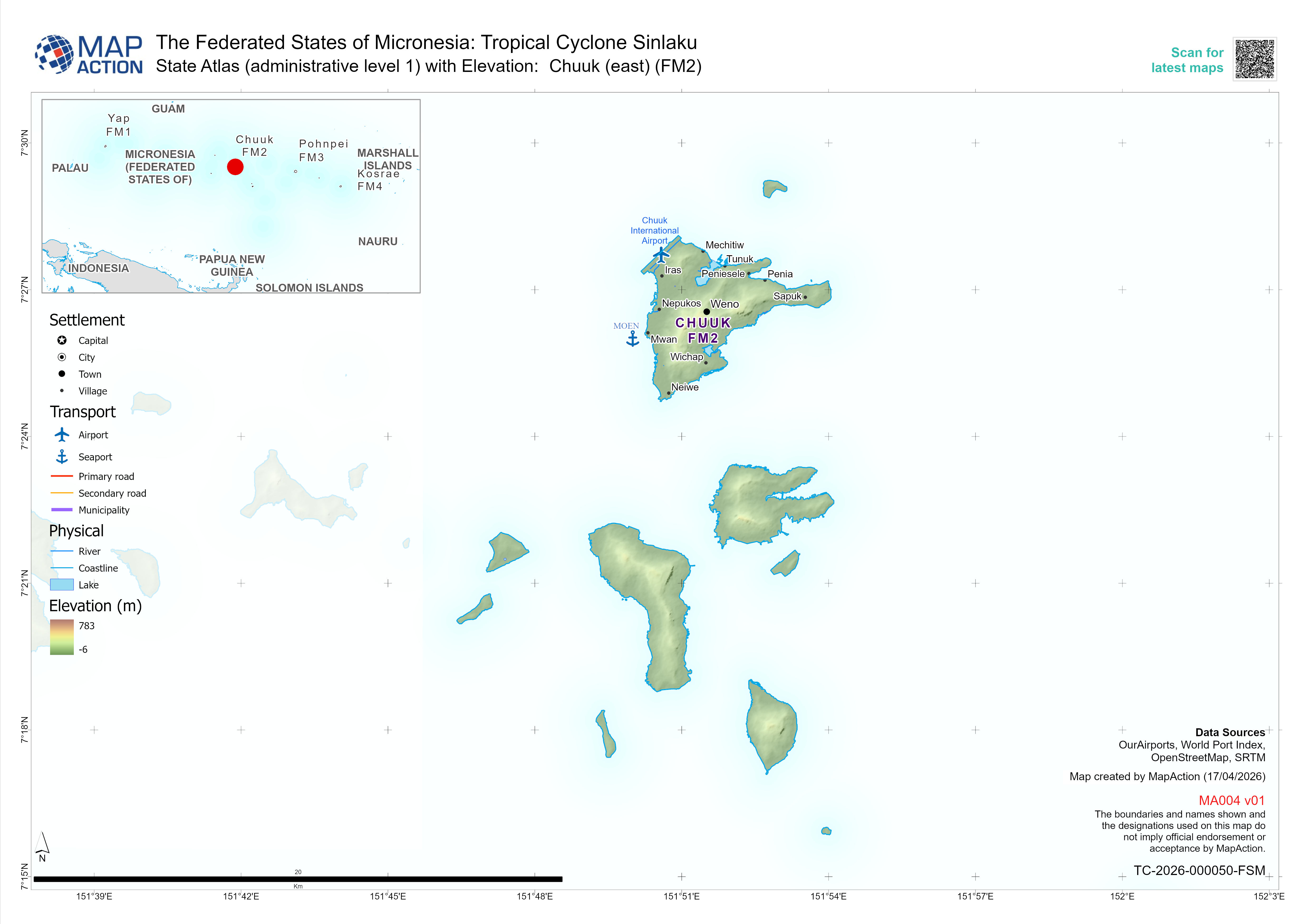
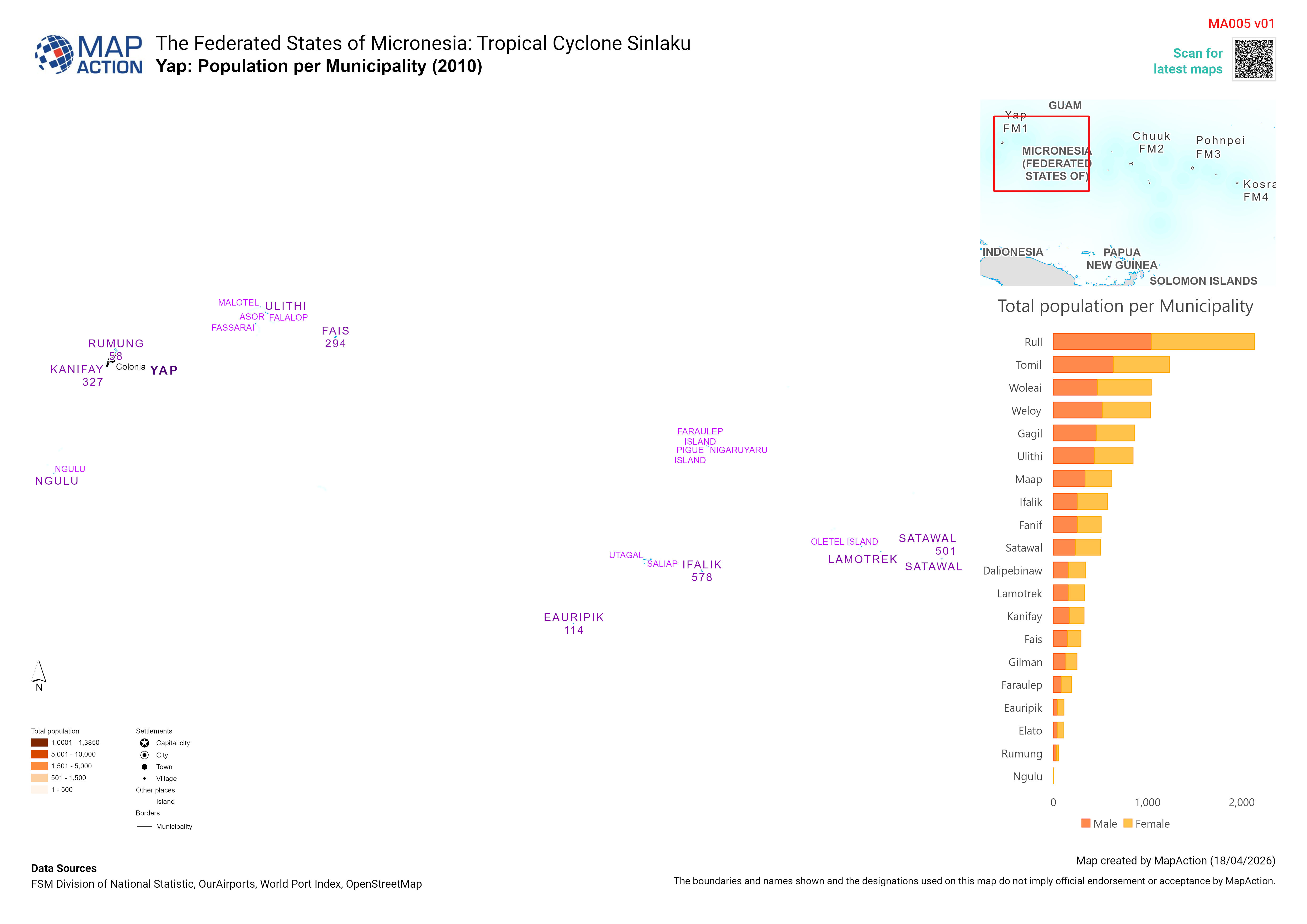
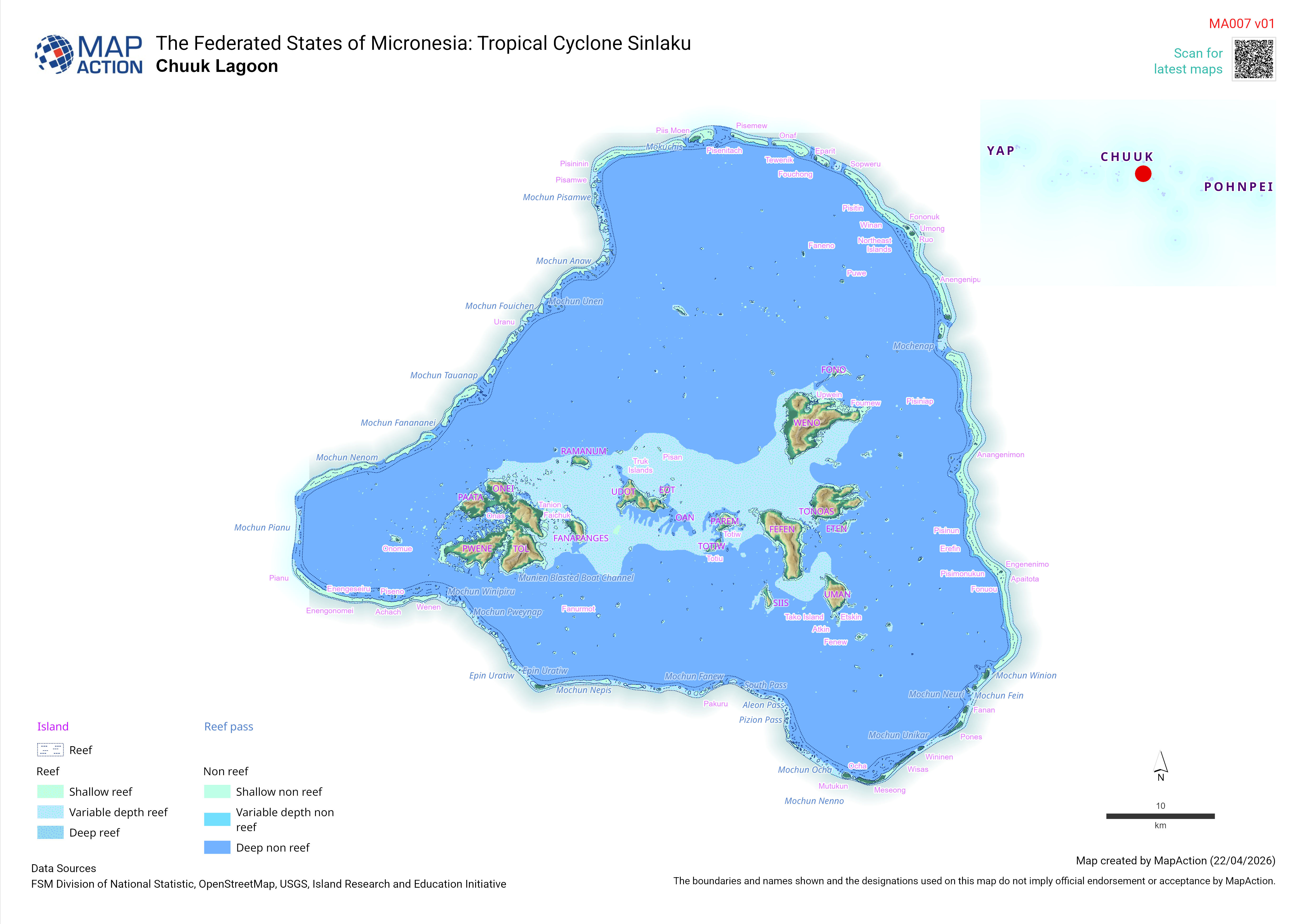
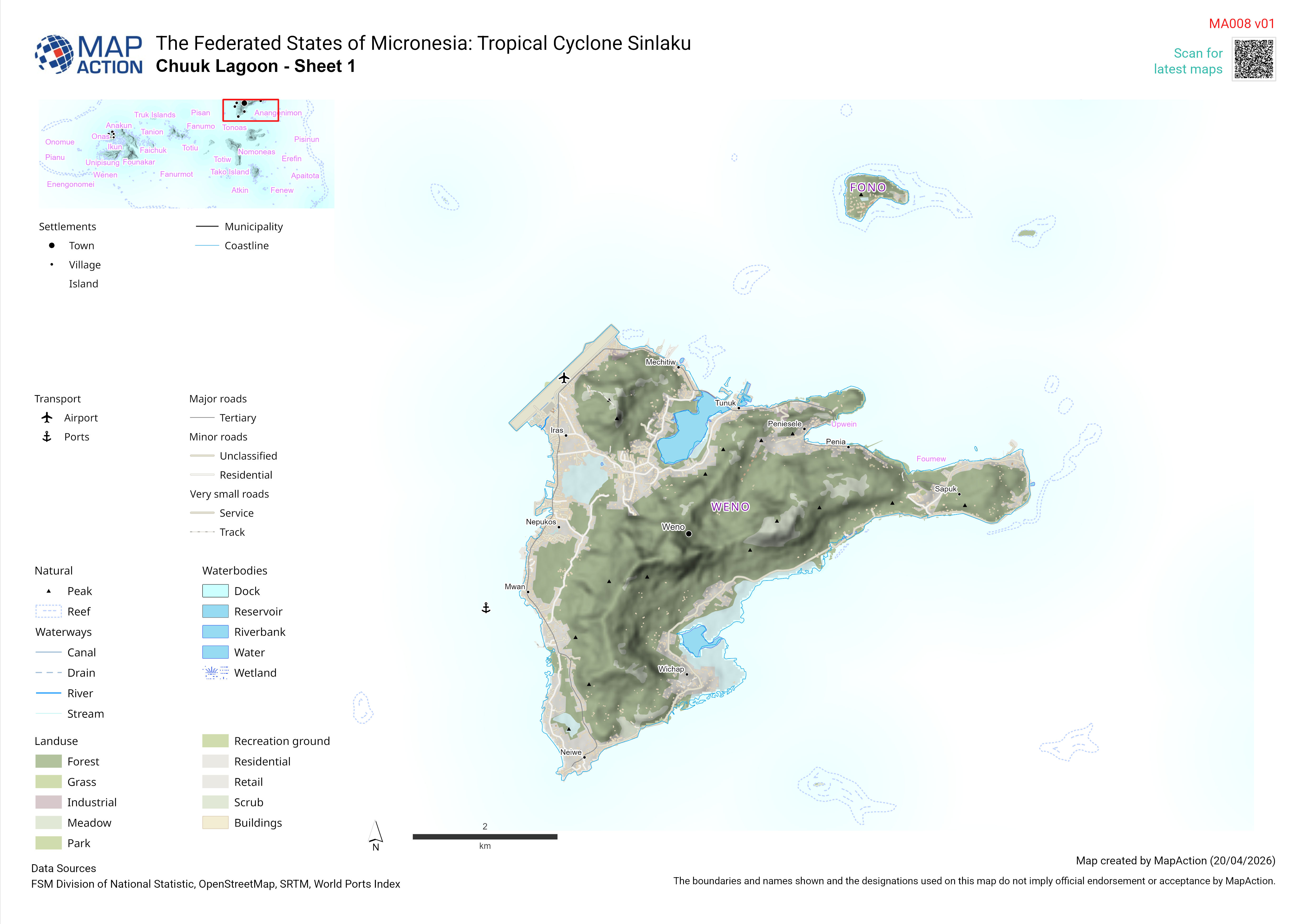
- Fiji: Cyclone Yasa, December 2020
-
Guatemala: Hurricanes Eta and Iota, November 2020
MapAction has deployed a three person team to Guatemala to support the UNDAC team in the ongoing response in the country in the aftermath of Hurricanes Eta and Iota. This response is supported by...
-
Honduras and regional: Hurricane Eta and Iota, November 2020
A coordinated team of MapAction GIS volunteers is working remotely in support of the UN Office for the Coordination of Humanitarian Affairs (OCHA) Regional Office for Latin America and Caribbean...
-
Typhoons, The Philippines, November 2020
A MapAction team member is supporting the ASEAN Coordinating Centre for Humanitarian Assistance on Disaster Management (AHA Centre) as it coordinates the response to the latest in a series of big...
-
Cambodia, Laos, Viet Nam: Floods, October 2020
MapAction is working with the ASEAN Coordinating Centre for Humanitarian Assistance on Disaster Management (AHA Centre) following widespread flooding and landslides in the Lower Mekong Region.This...
-
Latin America Regional: Preparedness, October 2020
A MapAction team member is providing full time support to the UN Office for Coordination of Humanitarian Affairs (OCHA) Regional Office for Latin America and the Caribbean (ROLAC) to assist with...
-
Beirut: Lebanon, August 2020
Following an explosion in the Beirut docks MapAction has sent a team to support the UN Disaster Assessment and Coordination (UNDAC) team. In support of the field team a remote team is working with...
-
Libya: WHO COVID-19 response
MapAction are providing remote support to World Health Organisation (WHO) Libya to provide support and advice for their Information Management (3w) as well as visualisation support (maps) for...
-
Syria: CCCM, May 2020
MapAction supported the Office for the Coordination of Humanitarian Affairs (OCHA) Turkey in response to the escalation of the refugee crisis across North West Syria in early 2020. The deployment...
-
Guyana: Training, March 2020
MapAction delivered a 2-week training course in QGIS and humanitarian mapping for the Civil Defense Commission (CDC) in Guyana which was supported by UNICEF.
-
Albania: Earthquake, November 2019
MapAction has been providing some remote support to the response in Albania following the earthquake that affected the country on 26th November.
-
Djibouti: Floods, December 2019
Two MapAction volunteers are travelling to Djibouti, East Africa, tomorrow at the request of the UN Disaster Assessment and Coordination (UNDAC) to assist the response to devastating floods that...
-
Laos PDR: Floods, September 2019
Tropical Storm Podul and tropical depression Kajiki have brought an estimated 40cm of rain to the southern provinces of Laos, affecting the lives of an estimated 572,000 people and significant...
-
The Bahamas: Hurricane Dorian, September 2019
Hurricane Dorian made landfall on the islands of Abaco and Grand Bahama in Northwest Bahamas. This storm has developed over the previous days into a slow moving and very dangerous hurricane. With...
-
Mozambique: Cyclone Idai, March 2019
On Friday 14 March, the intense tropical cyclone Idai struck the south-eastern coast of Africa with sustained wind speeds of 120mph. Heavy rain caused severe flooding. Hundreds of people are known...
-
Venezuala: Economic, Oct - Dec 2018
Large numbers of people have left Venezuela as a result of the economic crisis, and many of them are in Guyana. Since October 2018, MapAction has been working with the Civil Defence Commission and...
-
Nigeria: Floods, August 2018
A two person MapAction team is supporting UNDAC in Nigeria with its response to widespread flooding across much of the country.
- Indonesia: earthquake and tsunami, October 2018
-
The Philippines: Typhoon Mangkhut, September 2018
After forming in the north west Pacific, Typhoon Mangkhut reached the Philippines area as a category 5 equivalent hurricane on 12 September 2018 and is expected to cross northern Luzon island on 15...
-
Caribbean: Tropical Storm Isaac, August 2018
Tropical storm Isaac is currently entering the Caribbean and is expect to make landfall in the coming days
- Caribbean: Hurricane Maria, September 2019
- Bahamas and Turks and Caicos: Hurricanes, September 2017
- Anguilla and British Virgin Islands: Hurricane Irma, September 2017
-
Sierra Leone Landslides, August 2017
A seven person UNDAC team deployed on 18 August including three members of MapAction. Their role has been to provide support to the damage assessments, assistance in identifying the humanitarian...
- Tropical Cyclone Donna
-
Floods, Peru
Intense rains have caused widespread floods and landslides in Peru, reportedly affecting more than half the country. The floods have inundated key infrastructure, including hospitals and schools,...
-
Tropical Cyclone Enawo, Madagascar
Tropical Cyclone Enawo made landfall over Antalaha district on 7 March and has continued its path across the country. The storm has caused widespread damage across north-eastern and central-eastern...
- Chile Wildfires, January 2017
- Bahamas, October 2016
- Haiti, October 2016
-
Jamaica, October 2016
MapAction deployed to Jamaica at the request of the United Nations Disaster Assessment and Coordination (UNDAC) team to help support in initial assessments immediately after Hurricane MATTHEW had...
- Northern Nigeria, Floods
-
Tanzania, Earthquake, September 2016
At the request of the United Nations, a MapAction volunteer has deployed to Tanzania to support the response to an earthquake which struck the border area between Tanzania, Uganda and Rwanda on 10...
-
Cape Verde, August 2016
The smallest inhabited island of the Cape Verde archipelago, Brava (64 square km; population 6,000) has been experiencing since the 1st August strong and regular tremors at the core of the island...
-
Ecuador earthquake, April 2016
A 7.8 magnitude earthquake strikes north of country on 16 April. Two MapAction volunteers deploy to Ecuador to assist the Ecuadorian government with their emergency response.
-
Paraguay floods, April 2016
Five months of heavy rains lead to severe flooding and the need for evacuation.
-
Cyclone Winston, Fiji, February 2016
Cyclone Winston, the most powerful cyclone to hit Fiji since records began, makes landfall on 20 February. No detail on what we did.
-
Cyclone Chapala, Yemen, November 2015
Cyclone Chapala hits South Yemen on 3 November, causing severe flooding and widespread damage. No detail on what we did.
-
Refugee crisis, Mediterranean, October 2015
MapAction deploys volunteers to Athens, Belgrade and Geneva to support the coordination of the refugee crisis in the Mediterranean.
-
Tropical storm Erika, Dominica, September 2015
On 30th August Tropical Storm Erika swept through the island of Dominica causing flooding and landslides. The MapAction Latin America and Caribbean section provided remote support.
-
Nepal earthquake, April 2015
Devastating 7.8 strong earthquake hits Nepal on 25 April. MapAction volunteer is already in-country, quickly joined by larger team to help coordinate massive response effort.
-
Chile floods, March 2015
A state of emergency is declared in Atacama and Antofagasta after major flooding.
-
Cyclone Pam, Vanuatu, March 2015
Category 5 Cyclone Pam strikes Vanuatu on 13 March. MapAction team maps the needs of affected communities and helps coordinate the humanitarian response.
-
Malawi floods, January 2015
Severe flooding hits southern Malawi, causing widespread destruction. MapAction deploys a team to help with the response.
-
Cape Verde volcano, December 2014
Pico de Fogo on Cape Verde began to erupt on 23 November 2014. MapAction provided remote mapping support.
-
MapAction - ACAPS Publications
MapAction supports ACAPS with mapping capacity for their country analysis reports and other projects.
-
Ebola, Sierra Leone, October 2014
We send a highly experienced team to Sierra Leone to help coordinate the response to the Ebola outbreak there, providing mapping support to the Ebola Operations Centre in Freetown.
-
Ebola, Liberia, September 2014
As Ebola hits West Africa, MapAction deploys to Monrovia to help coordinate the national and international response to this medical emergency.
-
Iraq conflict, June 2014
Widespread conflict hits north and central Iraq. MapAction deploys to help collate and disseminate key data about the complex and evolving crisis, working with others to ensure everyone uses the...
-
Paraguay floods, June 2014
Floods in the north, south and east lead to call for international assistance. MapAction provides independent assessment of the situation, enabling teams to reflect on roles and procedures.
-
Serbia floods, May 2014
Sustained rainfall results in worst floods for over 100 years. No info on our response
-
South Sudan conflict, January 2014
Widespread fighting extends across the country, affecting hundreds of thousands. MapAction assesses the humanitarian impact of the violence and aid priorities.
-
Typhoon Haiyan (Yolanda), The Philippines, November 2013
Category 5 ‘super’ typhoon Haiyan makes landfall on 8 November. MapAction deploys immediately to support humanitarian operations in the worst-hit areas.
-
Cyclone Phailin, India, November 2013
Cyclone Phailin makes landfall in Odisha and Andhra Pradesh on 12 October. Doesn’t say what our response was
-
Sudan floods, September 2013
Heavy rain and flash floods severely affect several areas of Sudan. MapAction assists with GIS and IM support for the flooding response.
-
Cyclone Mehasan, Myanmar, May 2013
MapAction deploys to Myanmar in preparation for Cyclone Mehasan, producing recommendations on preparedness activities.
- Syria, 2013-2015
-
Cameroon/Central African Republic conflict, January 2013
MapAction deploys to Yaounde, Cameroon, to support response to ongoing violence and insecurity in the Central African Republic.
-
Typhoon Pablo (Bopha), The Philippines, December 2012
MapAction team deploys in readiness for Typhoon Pablo (Bopha).
-
Guatemala earthquake, November 2012
A 7.4-magnitude earthquake struck off the Pacific coast of Guatemala on 07 Nov 2012, killing at least 39 people, injuring another 155 and destroying scores of homes. 100 people may be missing in...
-
Paraguay floods, June 2012
The worst floods in more than a decade begin in April 2012, leaving thousands in urgent need of emergency aid. No detail on what we did
-
Comoros Floods, April 2012
Torrential rain has been battering the Comoros Islands in the Indian Ocean since 20 April, causing heavy flooding and landslides. A State of Emergency has been called.
-
Munitions explosion, Republic of Congo, March 2012
Following devastating explosions in a munitions depot in Brazzaville on 4 March, MapAction team deploys to produce sector maps to aid search and coordination, and records locations of ordnance found.
-
Madagascar floods, March 2012
Tropical Storm Irina, following on the heels of tropical Storm Giovanna, causes widespread devastation and flooding. MapAction deploys a team to help boost the government’s GIS capabilities to cope...
-
Sahel food crisis, Senegal, February 2012
Severe food crisis is forecast to strike the Sahel region, potentially affecting millions. A MapAction team assists with preparedness mapping.
-
Typhoon Washi (Sendong), The Philippines, January 2012
Typhoon Washi/Sendong hits south Philippines on 13 December 2011, causing more than 1,000 deaths and displacing millions. The mounting scale of response by the end of December leads to a request...
-
Nicaragua floods, October 2011
Torrential rain from Tropical Depression 12-E causes extensive flooding. Damage to roads and infrastructure leaves many communities cut off. MapAction supports response after government declares...
-
Post-election violence, Cote d’Ivoire, April 2011
Politically motivated violence in Abidjan and other areas threaten peace and security. MapAction team deploys to help obtain clear picture of humanitarian situation in the conflict-torn country.
-
Earthquake and tsunami, Japan, March 2011
An 8.9 magnitude earthquake strikes off coast of Oshika on 11 March, causing a tsunami. Doesn’t say what we did
-
Libya conflict, March 2011
Clashes between security forces and rebels cause hundreds of thousands to flee. MapAction teams are deployed to Tunisia and Egypt, to help with huge task of planning and logistics as people flee...
-
Hurricane Tomas, St Lucia, November 2010
St Lucia is badly hit by Hurricane Tomas on 30 October, causing landslides, blocked roads and cut off communities. Nothing on our work?
-
Pakistan floods, August 2010
Severe flooding in Islamabad region. MapAction provides situation mapping support for international agencies responding to the emergency.
-
Haiti earthquake, January 2010
A 7.0 magnitude earthquake strikes near Port-au-Prince on 12 January. MapAction deploys the next day, producing maps to aid search and rescue and creating a shared operational picture for relief...
-
Albania floods, January 2010
Two months of continuous rainfall leads to severe flooding in Shkodra and Lezha regions. MapAction assists with flooding assessments in the north of the country.
-
Pakistan landslide, January 2010
MapAction helped to alleviate risks of a potential flood catastrophe in mountainous northern Pakistan. The charity was approached by NGO leaders in Pakistan seeking assistance with risk and...
-
El Salvador floods, November 2009
Heavy rainfall around San Salvador causes flash flooding and landslides. Two MapAction team members deployed for 10 days to help with relief operations.
-
Sumatra earthquake, Sumatra, September 2009
Two earthquakes of 7.6 and 6.9 strike Padang, Sumatra, on 30 September. Four MapAction volunteers deployed to support the humanitarian response.
-
Typhoon Pepeng (Ondoy), The Philippines, September 2009
Tropical storm Ondoy causes mass destruction and flooding around Manila. MapAction team deploys to assist with information management and mapping.
-
Burkina Faso floods, September 2009
Flash floods in Ouagadougou destroy property and displace tens of thousands of people.
-
Benin floods, July 2009
Severe flooding in south of country leads government to request international assistance. MapAction team deploys in support.
-
Pakistan displacement emergency, June 2009
Clashes between Pakistani and Taliban forces in northwest Pakistan displace millions. MapAction team deploys to support international relief coordination.
-
Namibia floods, March 2009
Flooding affects substantial part of northern Namibia and the Caprivi Strip. A MapAction team deploys to assist in the humanitarian assessment operation.
-
Hurricane Ike, Haiti, September 2008
Hurricane Ike and other tropical storms bring devastating flooding centred on city of Gonaïves. MapAction deploys emergency mapping team as phase one response.
-
China earthquake, May 2008
A 7.8 magnitude earthquake struck Sichuan province in China on 12 May 2008.
-
Cyclone Nargis, Myanmar, May 2008
Cyclone Nargis devastates south of Myanmar and kills tens of thousands. MapAction team deploys to Bangkok for a month as integral component of rapidly assembled community of emergency agencies.
-
La Paz floods, Bolivia, January 2008
Severe flooding affects tens of thousands across the country. MapAction team helps steer evacuation planning and identifies campsite locations for displaced people.
-
Mexico City floods, November 2007
Mexico City and Tabasco province severely affected by exceptional seasonal rainfall. MapAction deploys emergency mapping team but is constrained by lack of government data.
-
Hurricane Noel, Dominican Republic, November 2007
Hurricane Noel brings severe flooding and cuts off dozens of villages. MapAction team responds to deployment request from the UN.
-
Northern Ghana floods, September 2007
Severe flooding affects much of northern Ghana. Team deploys to Tamale to assess situation by road and air. Maps distributed in-country and to donors.
-
Hurricane Dean, Jamaica, August 2007
Category 4 storm hits Jamaica on 20 August. Team deploys next day, producing vulnerability maps en route, taking part in rapid assessments and producing situation maps.
-
United Kingdom floods, July 2007
Severe flooding affected large areas of western and southern England during July 2007. MapAction assisted with overview mapping for responding agencies.
-
Islamabad flooding, Pakistan, July 2007
Severe flooding affects about a million people in southwest Pakistan. MapAction team member deploys in support of the UN’s response.
-
Garissa floods, Kenya, December 2006
Extensive flooding threatens tens of thousands in Garissa county. MapAction produces situation mapping, helps coordinate relief and advises on governmental IT infrastructure.
-
Suriname floods, May 2006
MapAction team deploys in response to severe flooding affecting communities along thousands of kilometres of river in the interior of the country.
-
Java earthquake and volcano, Indonesia, May 2006
A 6.4 magnitude earthquake strikes Yogiakarta, Java, on 27 May. MapAction team deploys and produces evacuation plan to mitigate further threat of volcanic eruption.
-
East Africa seismic risk, March 2006
Map produced for UNOCHA showing history of seismic activity in East Africa Rift Valley.
-
Pakistan earthquake, October 2005
A 7.6 magnitude earthquake strikes area around Muzzaffarabad, Kashmir, on 8 October. MapAction sets up operations in Pakistan within hours, creating a mapping unit and supporting disaster...
-
Niger food security, August 2005
Two MapAction volunteers are deployed to establish a GIS/mapping cell during a food crisis aggravated by severe drought and locust invasion.
-
Asian tsunami, December 2004
MapAction's first disaster response is to Sri Lanka in December 2004, in response to the catastrophic Indian Ocean tsunami.
-
Lesotho food security, October 2003
MapAction surveys and maps emergency food distribution infrastructure in southwest Lesotho ahead of crop failures that result in chronic food insecurity.
-
MapAction Resources
This is a list of additional resources