-

Japan Earthquake and Tsunami Affected Population of Tohoku 12:00 23rd March 2011
Map showing affected population figures broken down by prefecture together with 2010 National Census figures. -
Japan Earthquake and Tsunami Affected Population of Tohoku 17:00 22nd March 2011
Map showing affected population figures broken down by prefecture together with 2010 National Census figures. -

Japan Earthquake and Tsunami Affected Population of Tohoku 18:00 21st March 2011
Map showing affected population figures broken down by prefecture together with 2010 National Census figures. -

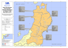
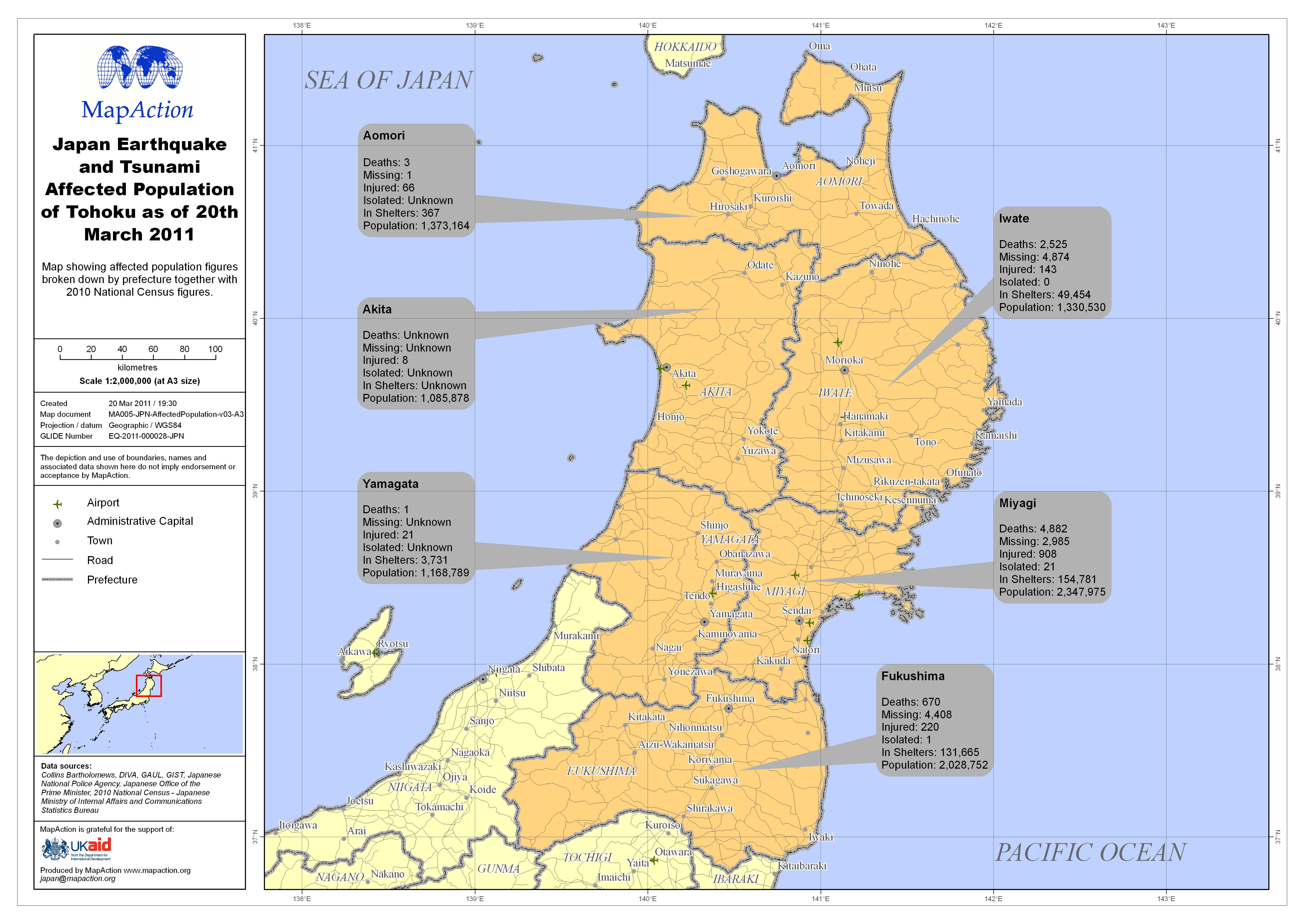
Japan Earthquake and Tsunami Affected Population of Tohoku as of 20th March 2011
Map showing affected population figures broken down by prefecture together with 2010 National Census figures. -

Japan Earthquake and Tsunami Affected Population of Tohoku as of 18th March 2011
Map showing affected population figures broken down by region together with 2010 National Census figures. -

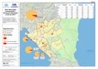
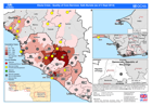
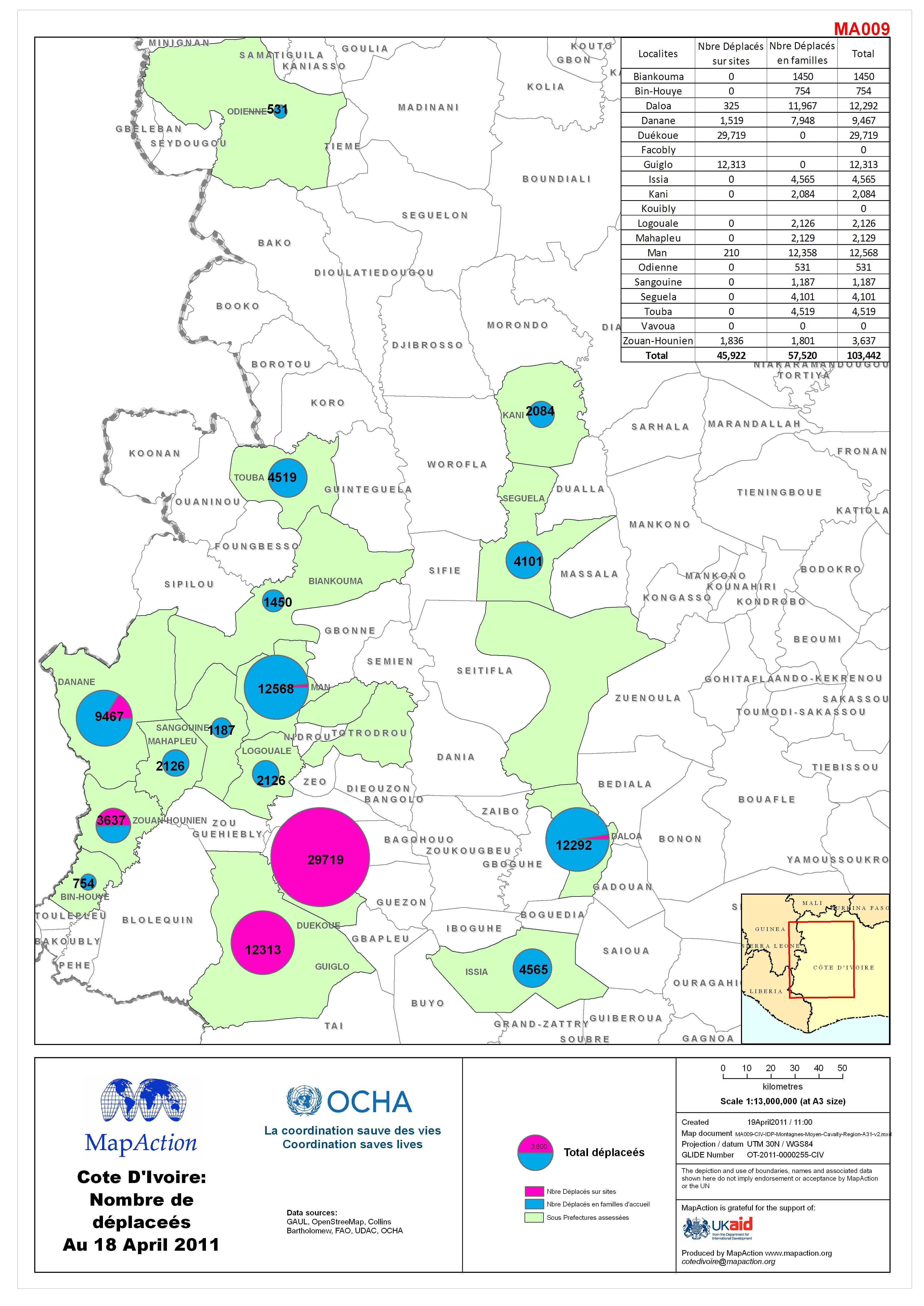
Côte d’Ivoire: Nombre de déplaceés Au 18 April 2011
Reference map for UNDAC mission to Côte d’Ivoire - April 2011. IDP numbers by Sous-Prefecture in Montagnes and Moyen-Cavally area of Côte d’Ivoire. Situation as assessed by mid... -
País: Nicaragua Inundaciónes - Personas Afectadas el 22 oct 2011
This dataset has no description
-
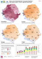
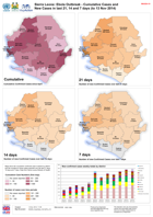
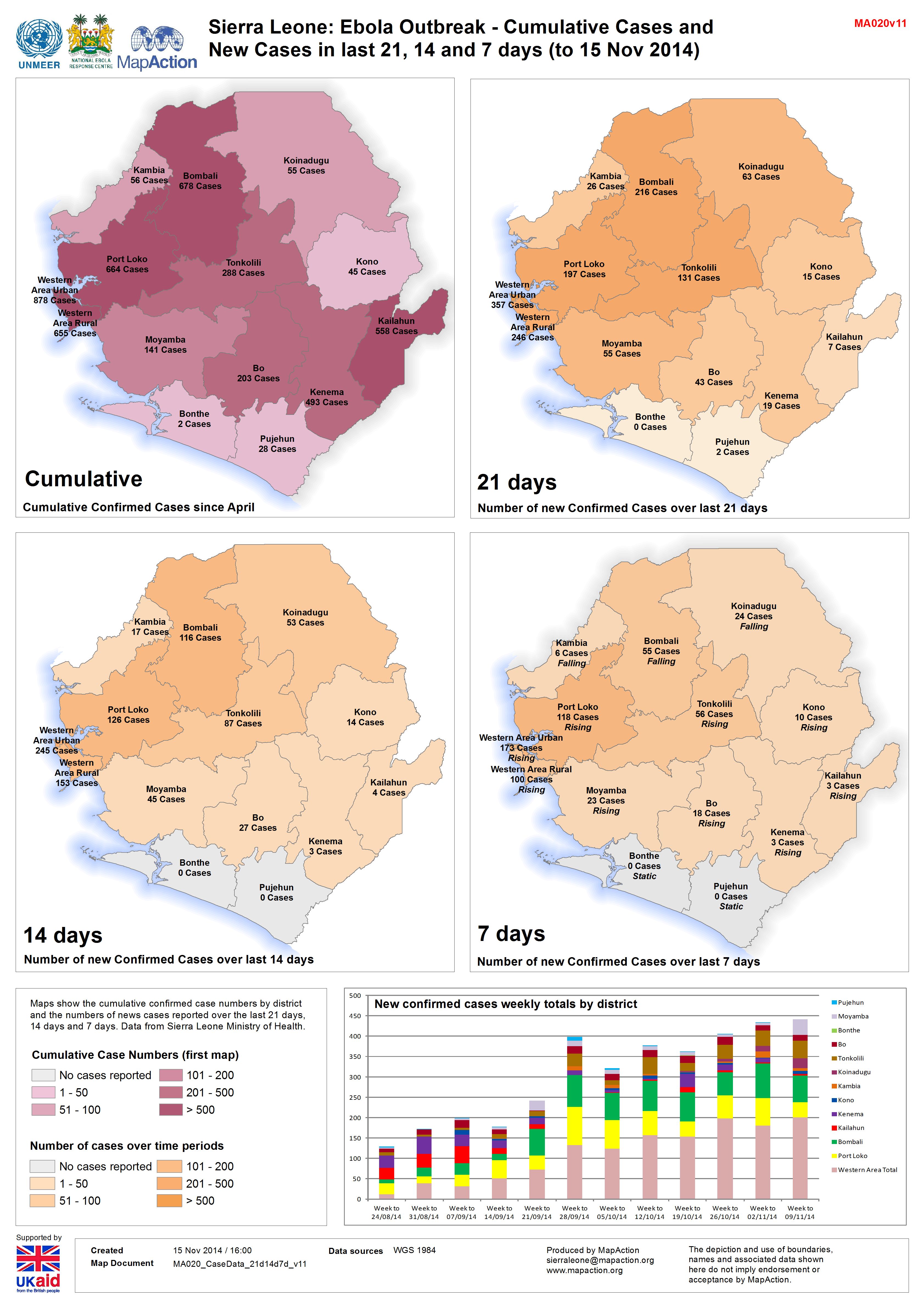
Sierra Leone: Ebola Outbreak - Cumulative Cases and New Cases in last 21, 14 ...
Maps show the cumulative confirmed case numbers by district and the numbers of news cases reported over the last 21 days, 14 days and 7 days. Data from Sierra Leone Ministry of... -

Sierra Leone Ebola Outbreak:Location & Status of Ebola Treatment Units and Cu...
Map shows the location and status of the known Ebola Treatment Units (as of 14/11/2014). Cumulative confirmed case totals and daily case movement/number (as of 14/11/2014) are... -
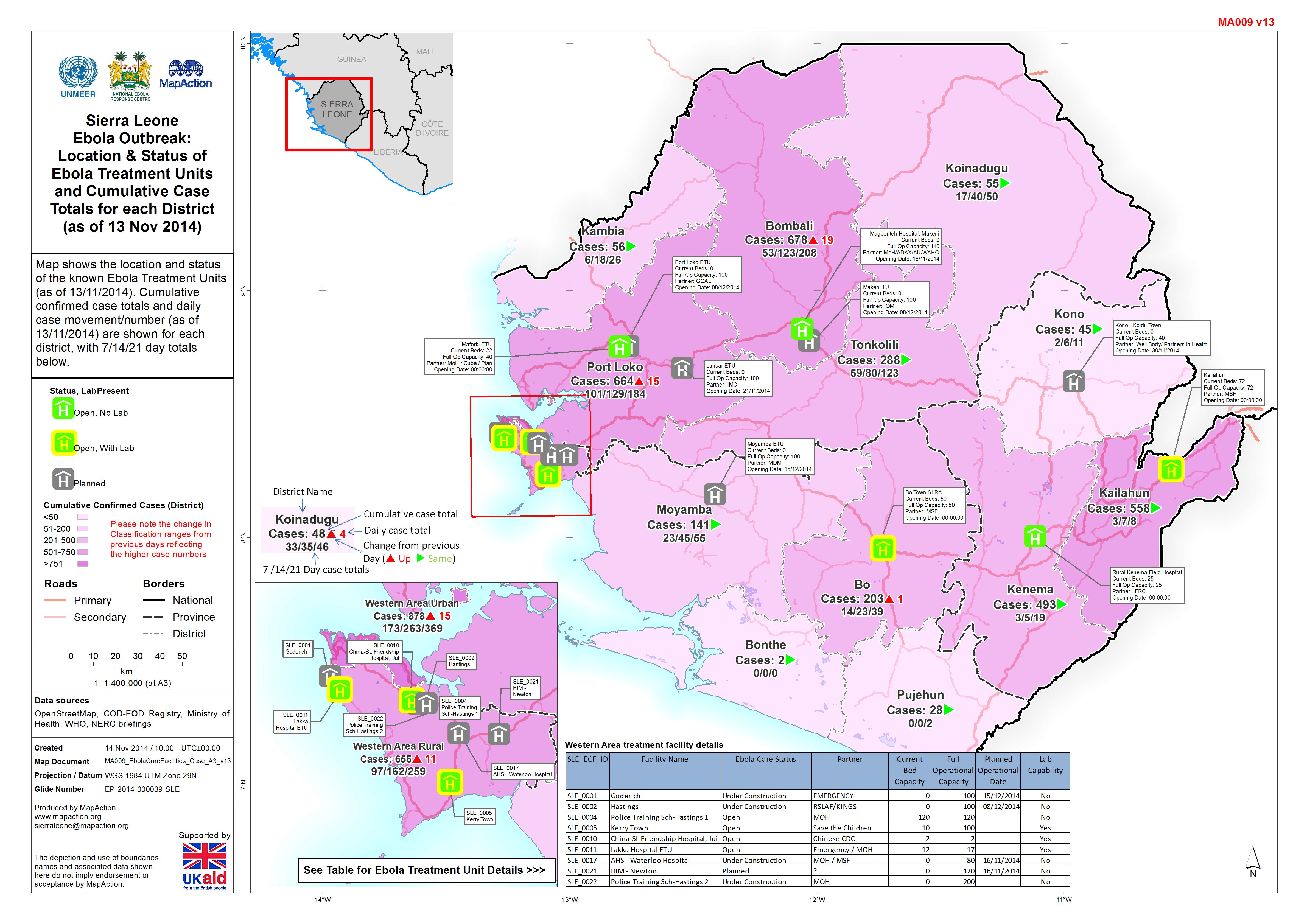
Sierra Leone Ebola Outbreak:Location & Status ofEbola Treatment Unitsand Cumu...
Map shows the location and status of the known Ebola Treatment Units (as of 13/11/2014). Cumulative confirmed case totals and daily case movement/number (as of 13/11/2014) are... -
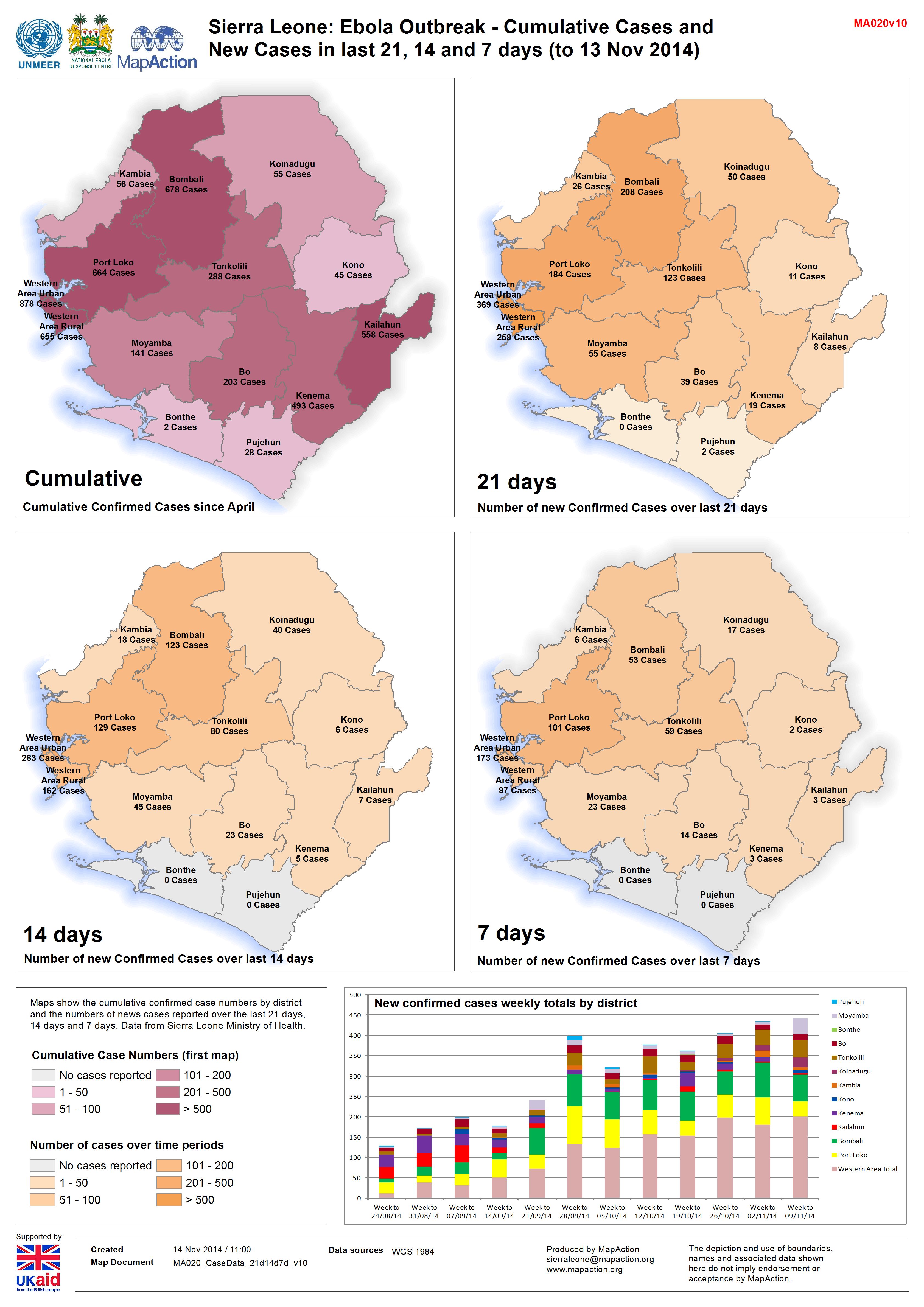
Sierra Leone: Ebola Outbreak - Cumulative Cases and New Cases in last 21, 14 ...
Maps show the cumulative confirmed case numbers by district and the numbers of news cases reported over the last 21 days, 14 days and 7 days. Data from Sierra Leone Ministry of... -
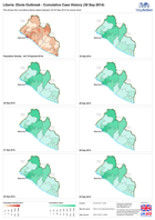
Liberia: Ebola Outbreak - Cumulative Case History (30 Sep 2014)
This shows the cumulative Ebola cases between 23-30 September 2014 at county level. -
Ebola Outbreak - Quality of Core Services: Safe Burials (as of 3 Sept 2014)
Map shows the status/quality of Safe Burials as of 3rd September, and Reported Cumulative Cases as of 1st September by Administrative levels 1 or 2 . If your... -

Ebola Outbreak - Quality of Core Services: Social mobilisation (as of 3 Sept ...
Map shows the status/quality of Social mobilisation as of 3rd September, and Reported Cumulative Cases as of 1st September by Administrative levels 1 or 2 . If your... -

Ebola Outbreak - Quality of Core Services: Emergency Treatment Centres (as of...
Map shows the status/quality of Emergency Treatment Centresas of 3rd September, and Reported Cumulative Cases as of 1st September by Administrative levels 1 or 2 . If your... -

Ebola Outbreak - Quality of Core Services: Laboratories (as of 3 Sept 2014)
Map shows the status/quality of Laboratories as of 3rd September, and Reported Cumulative Cases as of 1st September by Administrative levels 1 or 2 . If your... -
Ebola Outbreak - Quality of Core Services: Contact Tracing (as of 3 Sept 2014)
Map shows the status/quality of Contact Tracing as of 3rd September, and Reported Cumulative Cases as of 1st September by Administrative levels 1 or 2. If your... -

Ebola Outbreak - Quality of Core Services: Referral Centres (as of 3 Sept 2014)
Map shows the status/quality of Referral Centres as of 3rd September, and Reported Cumulative Cases as of 1st September by Administrative levels 1 or 2 . If your... -
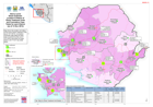
Malawi: Floods-Density of displacement sites(as of 18 Feb 2015)
Map shows the density of displacement sites that have been reported since the start of the flooding in Malawi. It does not reflect the status (open or closed) of the sites... -
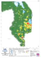
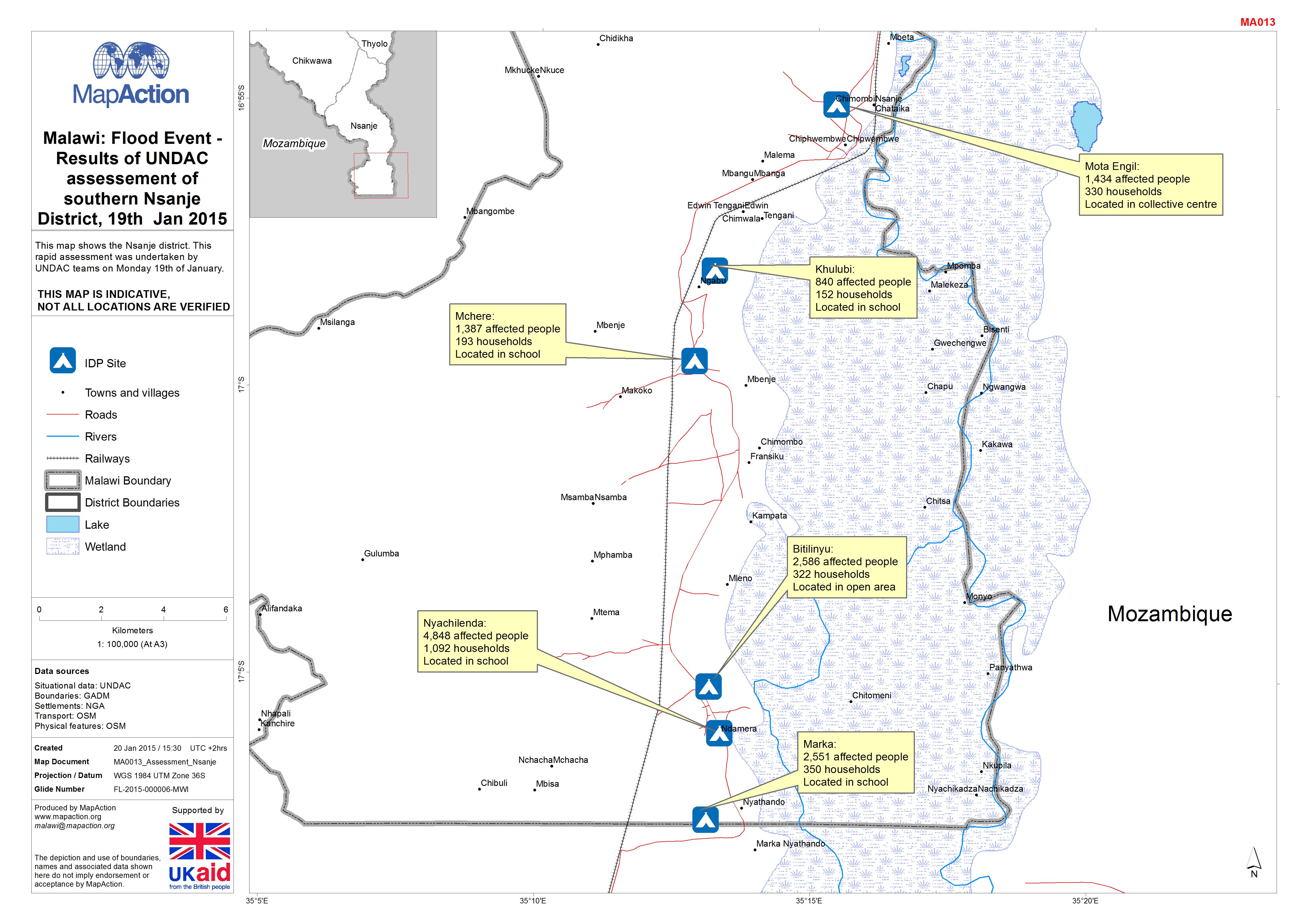
Malawi: Floods -Results of UNDAC assessement of southern Nsanje District, 19t...
This map shows the Nsanje district. This rapid assessment was undertaken by UNDAC teams on Monday 19th of January.