-
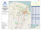
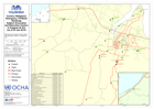
Philippines TS Washi (Sendong) Transitory Sites and Evacuation Centres for Ca...
Map shows the city of Cagayan de Oro and the location of Evacuation Centres / Transitory Sites as at 20th January 2012 -
Philippines Tropical Storm Washi (Sendong) Transitory Sites and Evacuation Ce...
Map shows the city of Cagayan de Oro and the location of Evacuation Centres / Transitory Sites as at 20th January 2012 -

Philippines Tropical Storm Washi (Sendong) Nutrition Cluster Who, What, Where...
Map shows the humanitarian organisations working on nutrition cluster activities at each Evacuation Centre (EC) / Transitory Site (TS) together with number of people at each... -

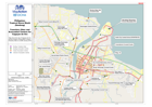
Philippines Tropical Storm Washi (Sendong) Affected Barangays and Evacuation ...
Map showing Barangays affected by Tropical Storm Washi with the locations of Evacuation Centres and Transitory sites (as of 18 January 2012) -

Philippines Tropical Storm Washi (Sendong) Calaanan 1, 2 and 3 Relocation Sites
Map shows the extent of the Calaanan Relocation Site with numbers of tents in different areas. The planned locations of Calaanan 2 and Calaanan 3 are shown in the overview map -

Philippines: Tropical Storm Washi (Sendong) - Shelter Cluster Who, What, Wher...
Map shows the number of houses damaged in Iligan by Barangay together with information on the humanitarian organisations working on shelter cluster activities in each Barangay... -
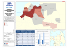
Philippines Tropical Storm Washi (Sendong) Housing Damage by Municipality - M...
Map shows number of damaged houses in each Municipality. Statistics are shown below including the number of houses totally or partially damaged in each Municipality (as at 10... -

Philippines, Emergency - TS Washi (Sendong), Subject: Evacuation Centre Popul...
Map of Cagayan de Oro showing the number of people in evacuation centres in each Barangay as of 12 Jan 2012. -

Philippines, Emergency - TS Washi (Sendong), Subject: Evacuation Centre Popul...
Map of Illigan showing number of people in evacuation centre in each Barangay as of 11 Jan 2012. -

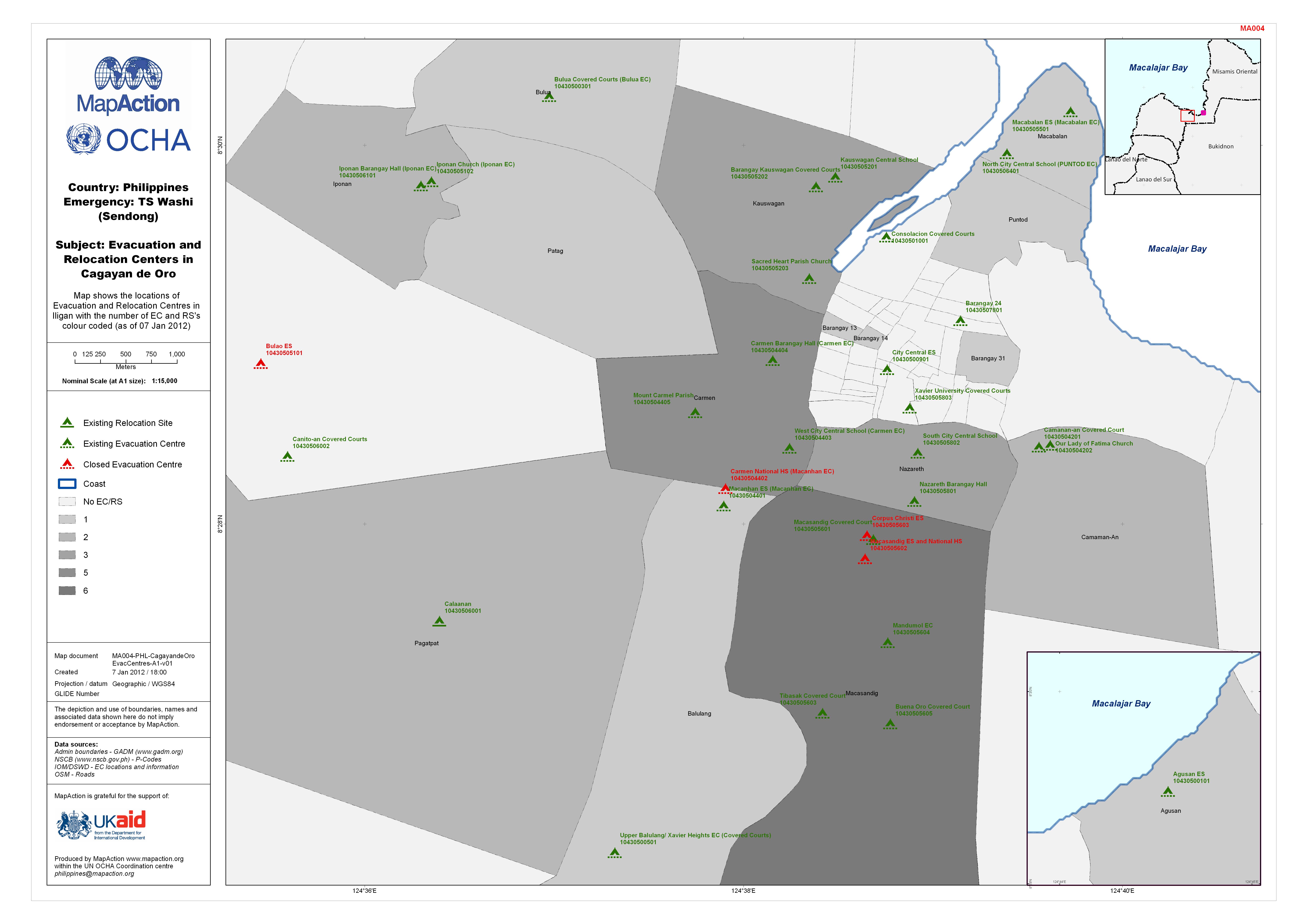
Philippines: TS Washi (Sendong) Subject: Evacuation and Relocation Centers in...
Map shows the locations of Evacuation and Relocation Centres in Iligan with the number of EC and RS's colour coded. (as of 07 Jan 2012) -
Philippines: TS Washi (Sendong) Subject: Evacuation and Relocation Centers in...
Map shows the locations of Evacuation and Relocation Centres in Iligan with the number of EC and RS's colour coded (as of 07 Jan 2012). -
Philippines: TS Washi (Sendong) Subject: Evacuation and Relocation Centers in...
Map shows the locations of Evacuation and Relocation Centres in Cagayan de Oro -

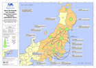
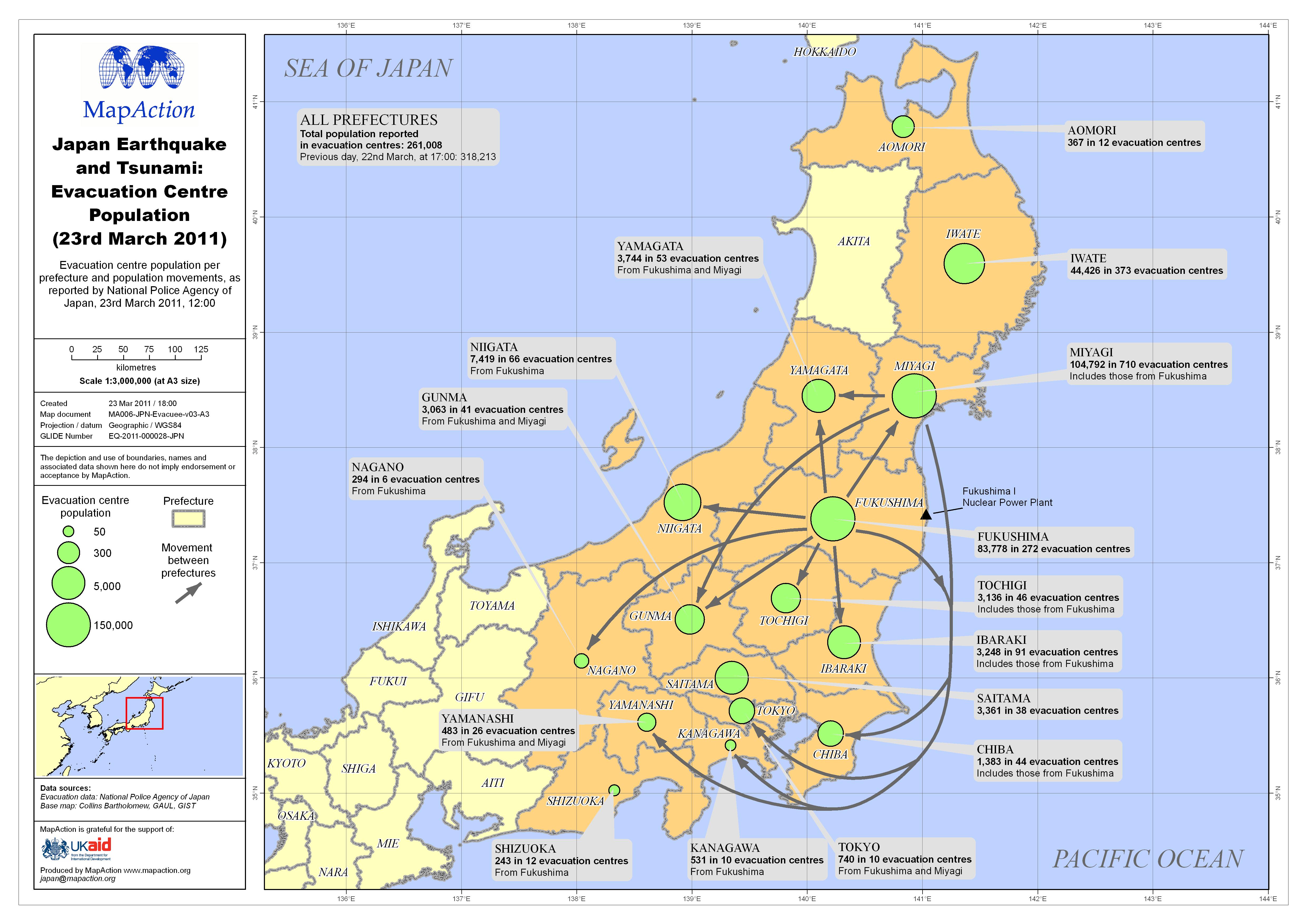
Japan Earthquake and Tsunami: Evacuation Centre Population (23rd March 2011)
Evacuation centre population per prefecture and population movements, as reported by National Police Agency of Japan, 23rd March 2011, 12:00 -
Japan Earthquake and Tsunami: Evacuation Centre Population (22nd March 2011)
Evacuation centre population per prefecture and population movements, as reported by National Police Agency of Japan, 22nd March 2011, 17:00 -

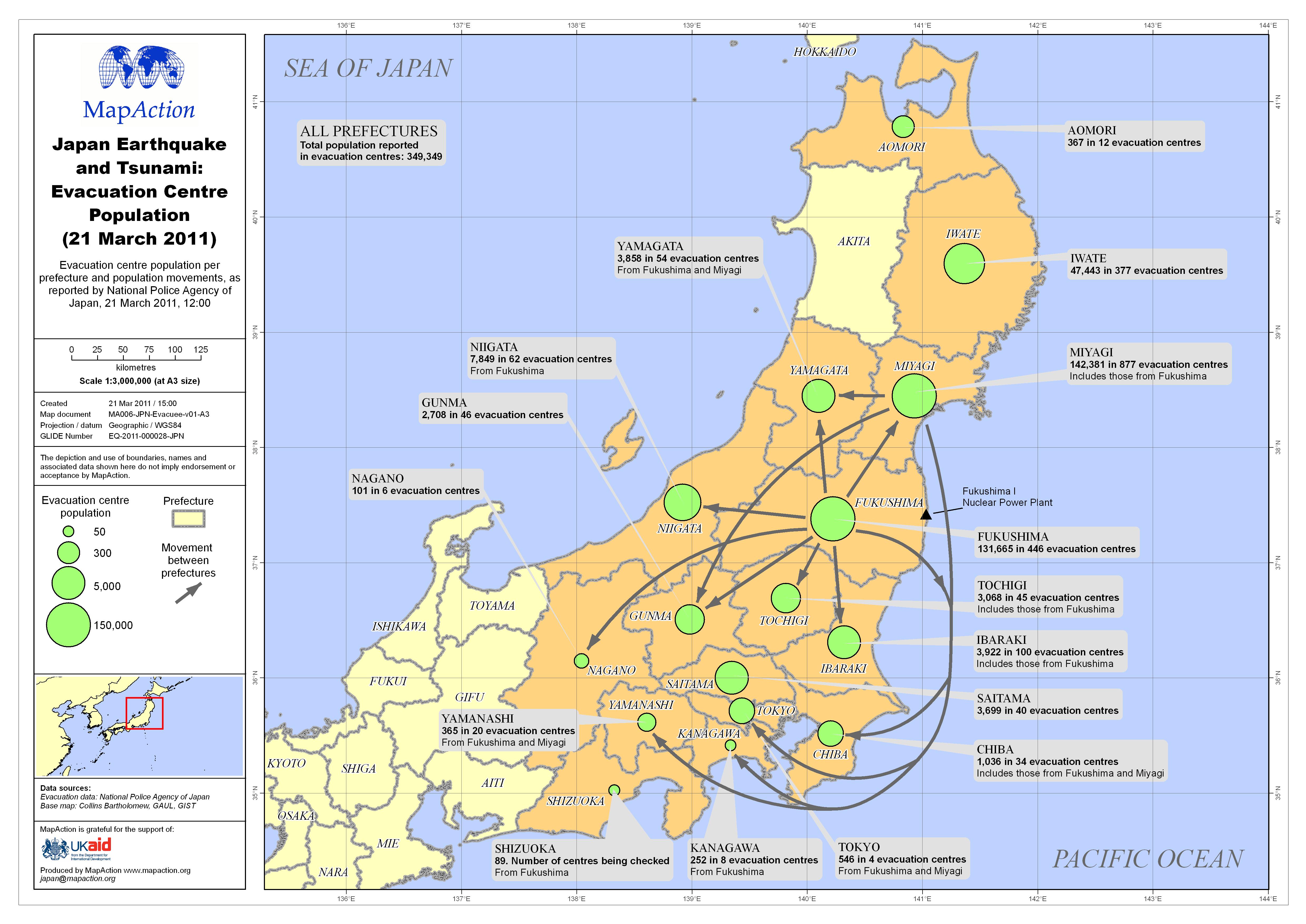
Japan Earthquake and Tsunami: Evacuation Centre Population (21 March 2011)
Evacuation centre population per prefecture and population movements, as reported by National Police Agency of Japan, 21 March 2011, 12:00 -

País: Nicaragua Inundaciónes - Albergues en Mangua el 22 oct 2011
This dataset has no description
-
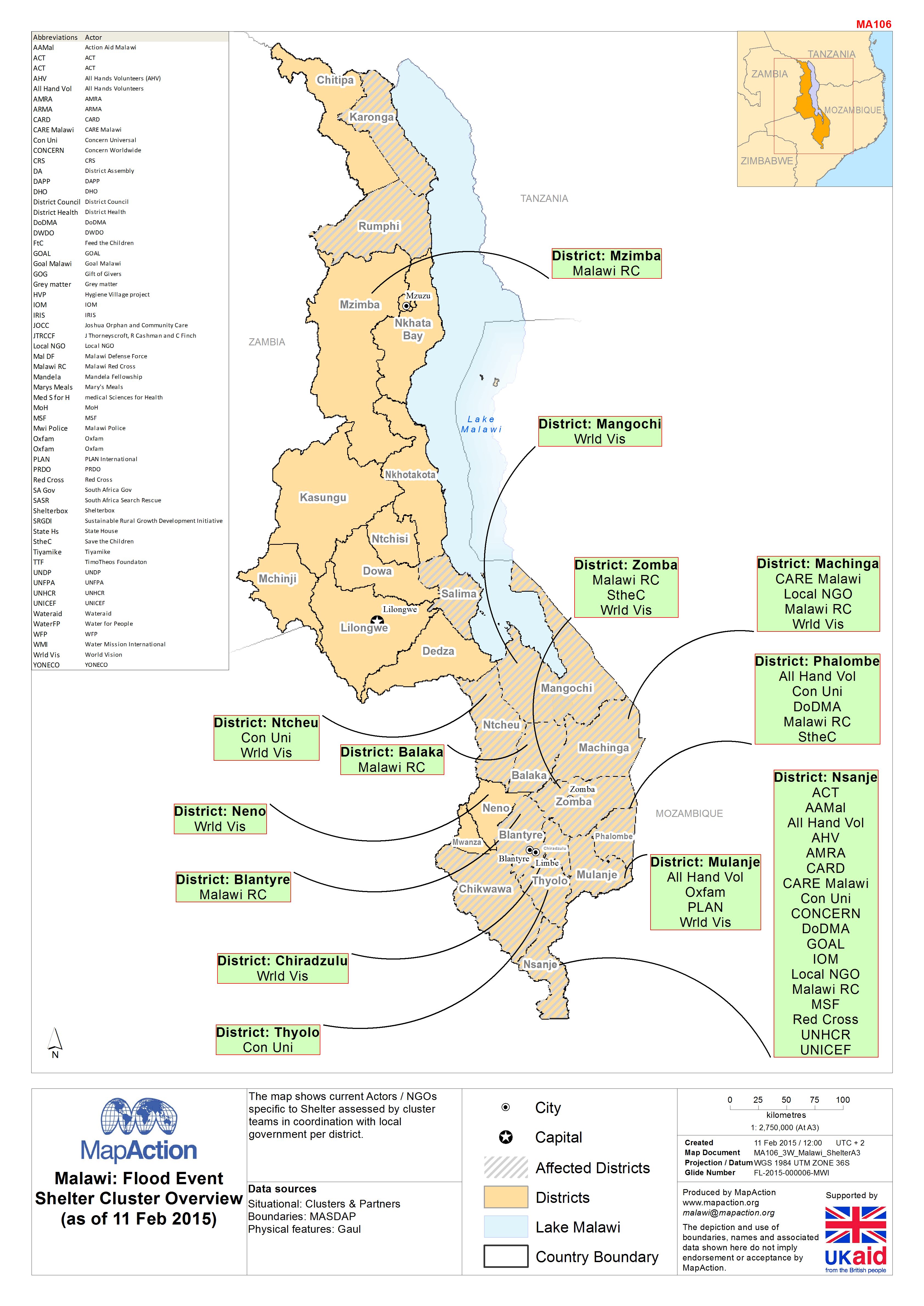
Malawi: Floods - Shelter Cluster Overview (as of 16 Feb 2015)
The map shows current actors / NGOs in the Shelter Cluster assessed by cluster teams in coordination with local government in each district. -

-
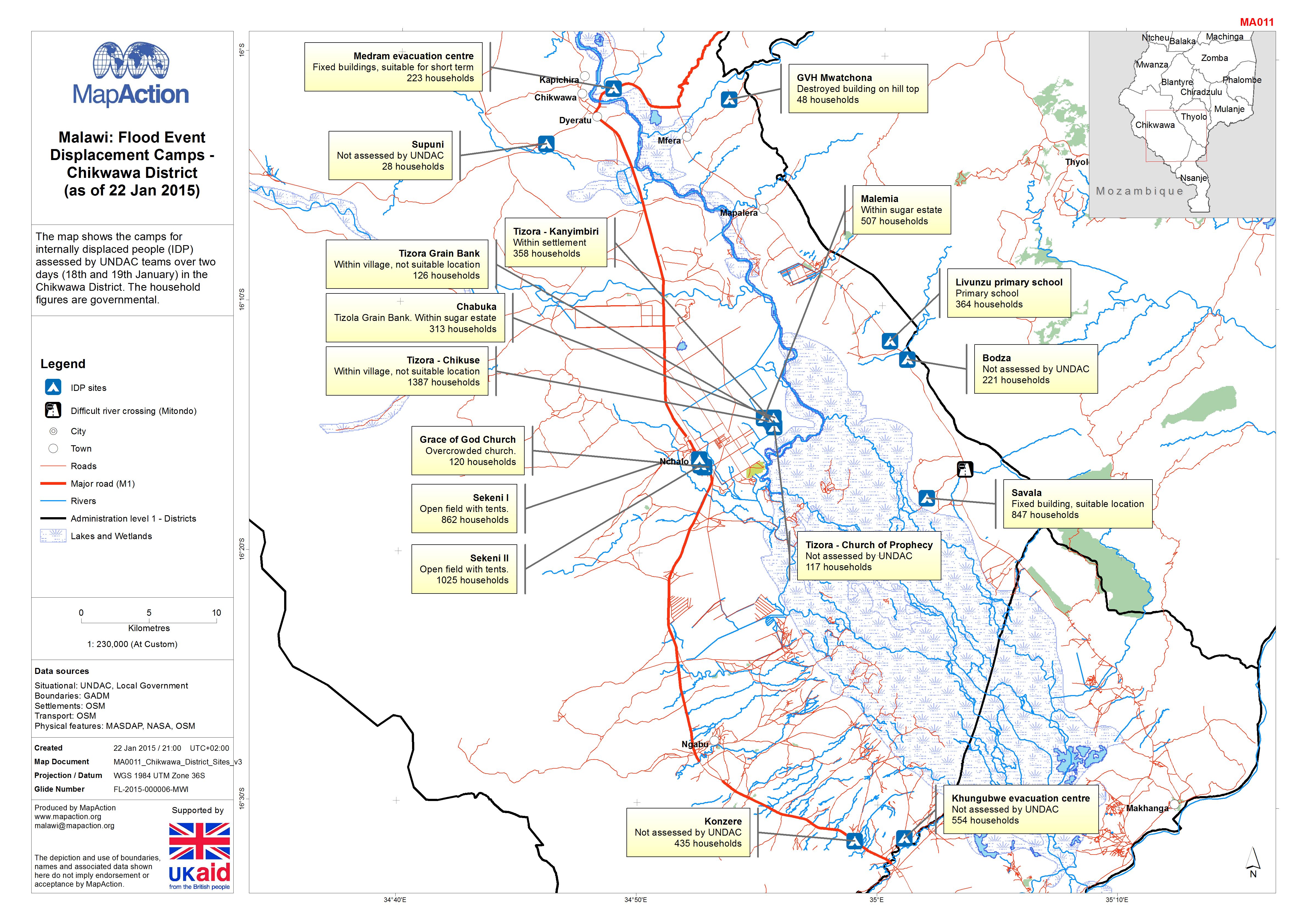
Malawi: Floods - Displacement Camps - Chikwawa District (as of 22 Jan 2015)
The map shows the camps for internally displaced people (IDP) assessed by UNDAC teams over two days (18th and 19th January) in the Chikwawa District. The household figures are... -
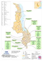
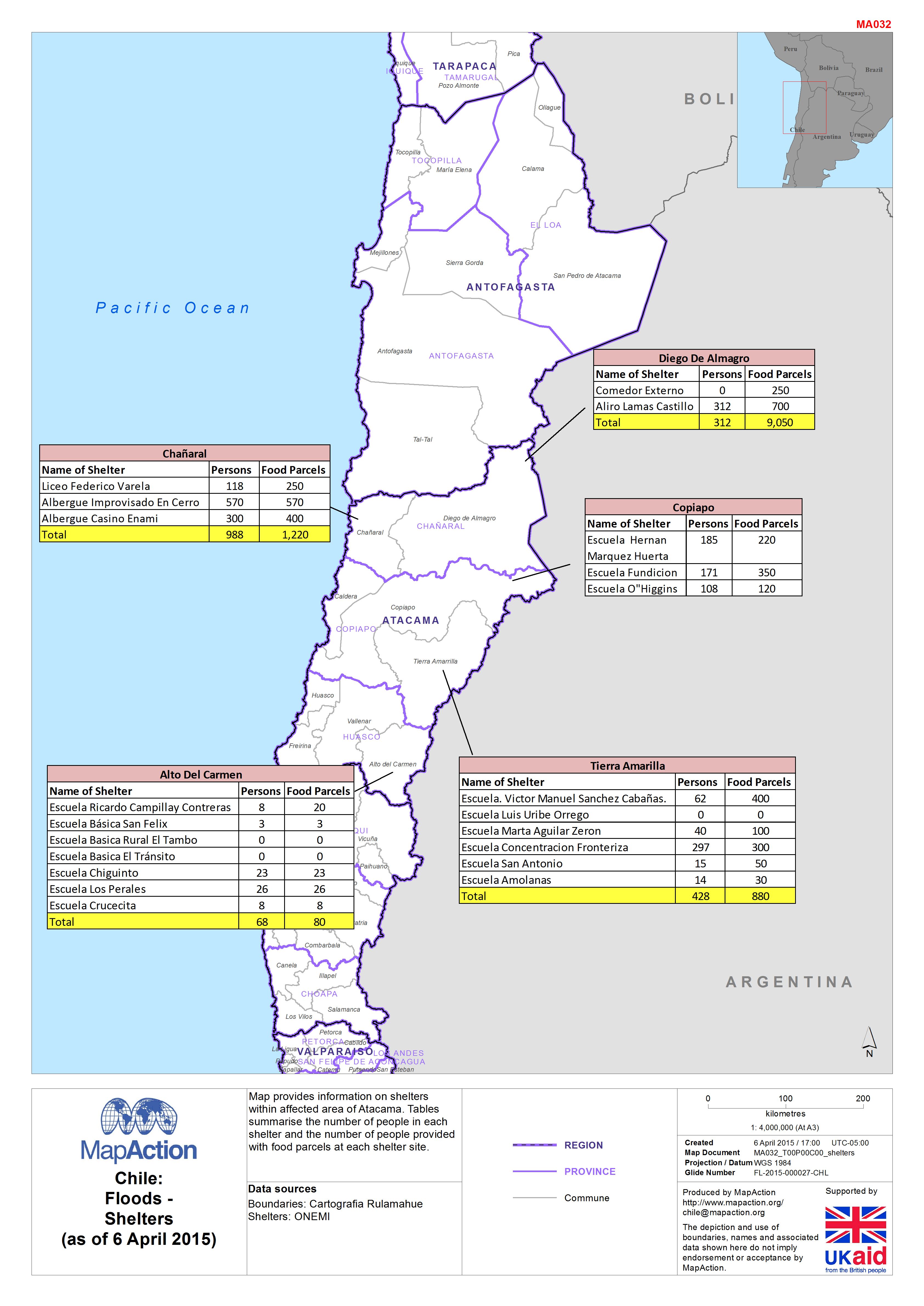
Chile:Floods -Shelters(as of 6 April 2015)
Map provides information on shelters within affected area of Atacama. Tables summarise the number of people in each shelter and the number of people provided with food parcels...