Skip to content
Log in
Register
Latest maps and data
Wildfires:
Belize
Hurricane Beryl: Caribbean
Menu
Home
About us
Impact
Strategy
Values
Where we work
History
Governance
Annual reports
Press
Services
Anticipatory Action/DRR
Health
Emergency response
Partners
Operational partners
Funders
Supporters
Team
Volunteer
Volunteer resources
News
Advocacy
Blog
LIVE Blogs
Anticipatory Action
Geospatial Community of Interest Asia-Pacific Newsletter. Sign-up Form
Maps
All maps and data
Example product catalogue
Other resources
Get involved
Fundraise
Corporate partnerships
Payroll giving
Trusts and foundations
Leave a gift in your will
Donation FAQs
Join us
Contact us
Donate
Locations
Events
Search Datasets
You are here:
Home
Maps and Data
Home
Datasets
Submit
Order by
Relevance
Name Ascending
Name Descending
Last Modified
Go
162 datasets found
Licenses:
License not specified
Locations or Events:
The Bahamas: Hurricane Dorian, September 2019
Filter Results
Flood extent data for Grand Bahama and Abaco as derived from Copernicus satel...
Flood extents for Abaco and Grand Bahama. Data for Abaco from 3/09/2019, data for Grand Bahama from 4/09/2019.
PDF
PDF
PDF
PDF
PDF
PNG
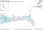
Grand Bahama Reference Map (as of 02 Sep 2019)
Map shows reference information for Grand Bahama including main settlement, roads, airports, ports, health facilities and education establishments.
JPEG
PDF
«
1
...
7
8
9
You can also access this registry using the
API
(see
API Docs
).
