thumbnail.png
From the dataset abstract
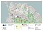
Map shows the extent and context of landslides from satellite images on 15 Aug 2017. Selected logistical sites and divisions are also shown.
Source: Sierra Leone Emergency - Landslide Overview (as of 19 Aug 2017)
Additional Information
| Field | Value |
|---|---|
| Data last updated | August 22, 2017 |
| Metadata last updated | August 22, 2017 |
| Created | August 22, 2017 |
| Format | PNG |
| License | Creative Commons Attribution |
| Has views | True |
| Id | ba6206aa-5e71-423d-9f8d-ffdab943c6c8 |
| On same domain | True |
| Package id | b992e561-5c37-4eda-89bd-aaab53647ddb |
| Position | 2 |
| Revision id | fa18aaef-41b8-4708-b717-be2da58ba7ff |
| State | active |
| Url type | upload |