thumbnail.png
From the dataset abstract
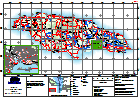
Shelter Map of Jamaica based on information provided by GoJ and referenced and extracted from OSM. Shelter data incomplete at time of production.
Source: Jamaica: Hurricane Matthew - Shelters (as of 2nd October)
Additional Information
| Field | Value |
|---|---|
| Data last updated | October 4, 2016 |
| Metadata last updated | October 4, 2016 |
| Created | October 4, 2016 |
| Format | PNG |
| License | License not specified |
| Has views | True |
| Id | c73001a4-3ac5-4a9b-8d21-d4d0190a7af3 |
| On same domain | True |
| Package id | 1d180962-1150-4cb1-ad4f-84eff6c9cddf |
| Position | 2 |
| Revision id | 2cca5702-a8a5-4f23-b1e6-2cf29f7a955d |
| State | active |
| Url type | upload |