thumbnail.png
From the dataset abstract
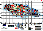
General Topography Map of Jamaica for orientation, including major settlement, topography and transport infrastructure.
Additional Information
| Field | Value |
|---|---|
| Data last updated | October 4, 2016 |
| Metadata last updated | October 4, 2016 |
| Created | October 4, 2016 |
| Format | PNG |
| License | License not specified |
| Has views | True |
| Id | 4c8fd5b5-ada3-498a-a427-ca004c46d5f7 |
| On same domain | True |
| Package id | 2f562363-6eec-4ab2-8cb7-a7e4a11aa3c7 |
| Position | 2 |
| Revision id | b5903576-22a0-42f1-9cb6-2fabfcd1e464 |
| State | active |
| Url type | upload |