thumbnail.png
From the dataset abstract
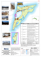
This map documents the damage resulting from Hurricane Irma across the Salt Cay island to public buildings and infrastructure as recorded by the Department of Disaster & Emergency...
Source: Turks & Caicos Islands Hurricane Irma Salt Cay Island Damage Situation Map (as of 13 Sep 2017)
Additional Information
| Field | Value |
|---|---|
| Data last updated | September 18, 2017 |
| Metadata last updated | September 18, 2017 |
| Created | September 18, 2017 |
| Format | PNG |
| License | License not specified |
| Has views | True |
| Id | 224b58bf-3817-48cd-b6ae-8c105019cf73 |
| On same domain | True |
| Package id | eafff1c4-09da-462b-829b-e2e9b260ed18 |
| Position | 2 |
| Revision id | ae29bc68-68c9-4339-93ff-c103df2d339f |
| State | active |
| Url type | upload |