thumbnail.png
From the dataset abstract
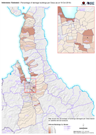
Map shows the percentage of buildings damaged per Desa based on satellite-derived analysis.
Source: Indonesia: Sulawesi - Percentage of damage buildings per Desa (as at 19 Oct 2018)
Additional Information
| Field | Value |
|---|---|
| Data last updated | October 21, 2018 |
| Metadata last updated | October 21, 2018 |
| Created | October 21, 2018 |
| Format | PNG |
| License | License not specified |
| Has views | True |
| Id | 392ffa2d-c827-474c-8b4c-c342a33c4811 |
| On same domain | True |
| Package id | 84042fe9-c616-416b-be47-3c45a9779d70 |
| Position | 2 |
| Revision id | e650e751-8d7f-4c6d-8160-ee14b34f6490 |
| State | active |
| Url type | upload |