thumbnail.png
From the dataset abstract
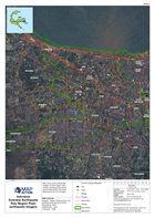
Map shows post-earthquake imagery of Palu region, with overlay showing areas where ground disturbance has been detected by ALOS-2 imagery.
Source: Indonesia Sulawesi Earthquake Palu Region Post-earthquake Imagery
Additional Information
| Field | Value |
|---|---|
| Data last updated | October 9, 2018 |
| Metadata last updated | October 9, 2018 |
| Created | October 9, 2018 |
| Format | PNG |
| License | License not specified |
| Has views | True |
| Id | baaa27af-5012-4ab1-ac9c-ceb645c13272 |
| On same domain | True |
| Package id | b1cc9203-f7ec-4ff7-889e-8706fe804bf3 |
| Position | 2 |
| Revision id | 1f02735c-5890-48be-b7e1-3ed5ea7695c6 |
| State | active |
| Url type | upload |