thumbnail.png
From the dataset abstract
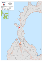
Maps shows the main roads and settlements of the Pula and Donggala districts of Central Sulawesi, Indonesia
Source: Indonesia Sulawesi Earthquake Donggala and Palu Infrastructure
Additional Information
| Field | Value |
|---|---|
| Data last updated | October 3, 2018 |
| Metadata last updated | October 3, 2018 |
| Created | October 3, 2018 |
| Format | PNG |
| License | License not specified |
| Has views | True |
| Id | 7d9f1152-7de5-48a2-9319-760366c87ef9 |
| On same domain | True |
| Package id | 6744ac6c-f922-4628-b46d-c4083b384c8c |
| Position | 2 |
| Revision id | 7ac257d6-6bba-49cf-b0e1-9aa99316e4d2 |
| State | active |
| Url type | upload |