thumbnail.png
From the dataset abstract
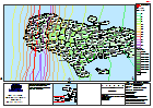
Reference map showing main affected areas of Haiti following hurricane Matthew, including track and estimated population at Section level.
Source: Haiti: Hurricane Matthew, Population Affected - (as of 7 Oct 2016)
Additional Information
| Field | Value |
|---|---|
| Data last updated | October 7, 2016 |
| Metadata last updated | October 7, 2016 |
| Created | October 7, 2016 |
| Format | PNG |
| License | License not specified |
| Has views | True |
| Id | 562838bd-2fa0-4989-b26e-55ce140e2550 |
| On same domain | True |
| Package id | 7546821c-551d-4016-94c3-3f5a4f926985 |
| Position | 2 |
| Revision id | 7447024a-6f6f-4ee3-bba7-5a78501ed697 |
| State | active |
| Url type | upload |