thumbnail.png
From the dataset abstract
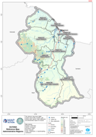
This reference map shows digital elevation data at 90m resolution, with primary roads, airports, major settlements and administrative regions for Guyana.
Additional Information
| Field | Value |
|---|---|
| Data last updated | April 7, 2020 |
| Metadata last updated | April 7, 2020 |
| Created | April 7, 2020 |
| Format | PNG |
| License | Creative Commons Attribution |
| Has views | True |
| Id | 53f7d903-df99-40ba-9556-9ef7dc1c47dd |
| Mimetype | image/png |
| On same domain | True |
| Package id | 0968d1c5-c0c4-489f-bbd7-c8fe83c0cc01 |
| Position | 2 |
| Revision id | 8a1d3c49-8fe7-49ef-b38e-757c5cfeaa42 |
| Size | 25.6 KiB |
| State | active |
| Url type | upload |