thumbnail.png
From the dataset abstract
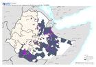
Map shows the location of the main cropping lands, the position of locusts and the woreda affected by locusts.
Source: Ethiopia: Woreda and main cropping land affected by locuts (Jan - Jul 2020)
Additional Information
| Field | Value |
|---|---|
| Data last updated | August 25, 2021 |
| Metadata last updated | August 25, 2021 |
| Created | August 25, 2021 |
| Format | PNG |
| License | License not specified |
| Has views | True |
| Id | 0b3e9a0e-0ca1-4295-98e7-c71ce79cf4d6 |
| Mimetype | image/png |
| On same domain | True |
| Package id | 41f4713f-ec39-43dc-8e6e-c1ab6dd9dbbb |
| Position | 2 |
| Revision id | 5a6ead4b-c426-4673-b140-6959e87eccdd |
| Size | 17.4 KiB |
| State | active |
| Url type | upload |