thumbnail.png
From the dataset abstract
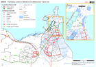
Djibouti - Floods - Key Buildings around Djibouti Ville. Map shows locations of key buidings from government and OSM sources and whether they are likely to have been affected by the...
Source: Djibouti: Key Building Locations in affected and non-affected zones - Djibouti Ville
Additional Information
| Field | Value |
|---|---|
| Data last updated | December 16, 2019 |
| Metadata last updated | December 16, 2019 |
| Created | December 16, 2019 |
| Format | PNG |
| License | License not specified |
| Has views | True |
| Id | b3025093-31f5-4750-98b0-6373ffc75fc8 |
| Mimetype | image/png |
| On same domain | True |
| Package id | 5e6cb34c-ceb6-43b1-b656-46c91aad8ae2 |
| Position | 2 |
| Revision id | e46d47f5-7379-4a5c-b150-abdd9f091349 |
| Size | 20.3 KiB |
| State | active |
| Url type | upload |