thumbnail.png
From the dataset abstract
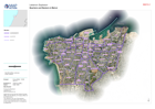
Map shows the admininistrative areas of Beirut Governorate. These called Cadasters and Neighbourhoods.
Additional Information
| Field | Value |
|---|---|
| Data last updated | August 6, 2020 |
| Metadata last updated | August 6, 2020 |
| Created | August 6, 2020 |
| Format | PNG |
| License | Creative Commons Attribution |
| Has views | True |
| Id | 7186aea7-9578-4d04-9f18-d132c474a387 |
| Mimetype | image/png |
| On same domain | True |
| Package id | 80b9a6f9-fadb-448b-8059-e6f9b2624b0e |
| Position | 2 |
| Revision id | 99385764-b904-41a6-80f6-21800230b05c |
| Size | 16.6 KiB |
| State | active |
| Url type | upload |