thumbnail.png
From the dataset abstract
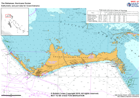
Bathymetry and ports data for Grand Bahama and Abaco. NOT TO BE USED FOR NAVIGATION. These charts are based on pre-hurricane Dorian data.
Additional Information
| Field | Value |
|---|---|
| Data last updated | September 6, 2019 |
| Metadata last updated | September 6, 2019 |
| Created | September 6, 2019 |
| Format | PNG |
| License | License not specified |
| Has views | True |
| Id | df3c1bd2-3ccf-4355-afb3-f2341baf1b58 |
| Mimetype | image/png |
| On same domain | True |
| Package id | 15eb4faf-856d-4891-9d43-f8db2e72e898 |
| Position | 4 |
| Revision id | 1cca103b-d420-475a-88ca-277278fbd997 |
| Size | 23.3 KiB |
| State | active |
| Url type | upload |