thumbnail.png
From the dataset abstract
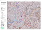
Daily overview map showing known road status and selected towns and localities in affected areas.
Source: Situation overview map
Additional Information
| Field | Value |
|---|---|
| Data last updated | July 4, 2016 |
| Metadata last updated | July 4, 2016 |
| Created | July 4, 2016 |
| Format | PNG |
| License | License not specified |
| Has views | True |
| Id | 1ab4cf65-8558-48b9-adb9-5ae7a050c343 |
| On same domain | True |
| Package id | 34744ab3-8fad-4386-8aca-b02e34adff72 |
| Position | 1 |
| Revision id | ee6a5c5b-9bca-4d34-82e0-5f4e6022472c |
| State | active |
| Url type | upload |