thumbnail.png
From the dataset abstract
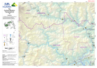
1:100,000 topographical map of Fiji showing physical, transport, settlement and other key features.
Source: Fiji: Cyclone Winston - Topographical - 53 - Laselevu
Additional Information
| Field | Value |
|---|---|
| Data last updated | July 28, 2016 |
| Metadata last updated | July 28, 2016 |
| Created | July 28, 2016 |
| Format | PNG |
| License | License not specified |
| Has views | True |
| Id | aa4a280f-b55d-41d3-ada5-03e1497b0d16 |
| On same domain | True |
| Package id | 400028d6-3807-4b64-9552-7f35bb936b2a |
| Position | 2 |
| Revision id | d4cc66e3-a266-428a-9efd-3044ab3c7b8e |
| State | active |
| Url type | upload |