thumbnail.png
From the dataset abstract
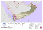
Map shows coastal ports in Yemen and Oman together with the land terrain and major roads.
Source: Yemen: Tropical Cyclone Chapala - Ports in Yemen and Oman
Additional Information
| Field | Value |
|---|---|
| Data last updated | July 28, 2016 |
| Metadata last updated | July 28, 2016 |
| Created | July 28, 2016 |
| Format | PNG |
| License | License not specified |
| Has views | True |
| Id | a914d136-fff2-407f-ad2f-a04b73d437b9 |
| On same domain | True |
| Package id | 5046f8f2-39c6-4983-a076-d5bdbd4fe5ab |
| Position | 2 |
| Revision id | ba17a5fb-da1d-424a-86f8-bb14669a8752 |
| State | active |
| Url type | upload |