thumbnail.png
From the dataset abstract
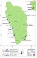
Map shows the locations and numbers of destroyed buildings. Numbers for Loubiere include Fond Baron, Citroniere, Castle Comfort and Newtown.
Source: Dominica Tropical Storm Erika - Destroyed Buildings (as of 17 Sep 2015)
Additional Information
| Field | Value |
|---|---|
| Data last updated | July 4, 2016 |
| Metadata last updated | July 4, 2016 |
| Created | July 4, 2016 |
| Format | PNG |
| License | License not specified |
| Has views | True |
| Id | bfa98ebc-3469-4f0d-b9d0-3d299df5306a |
| On same domain | True |
| Package id | 01dc5f16-2bcb-4d61-bab2-5340a1f2ea23 |
| Position | 2 |
| Revision id | e3d917ef-f431-4b6e-bbcd-82875a742955 |
| State | active |
| Url type | upload |