thumbnail.png
From the dataset abstract
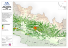
Map shows the density of buildings per 200m², indicating location of communities and their density. Building density derived from taking the centroid of each building footprint from OSM...
Source: Nepal: Earthquake - Building Density per 200m²(as of 28 May 2015)
Additional Information
| Field | Value |
|---|---|
| Data last updated | July 28, 2016 |
| Metadata last updated | July 28, 2016 |
| Created | July 28, 2016 |
| Format | PNG |
| License | License not specified |
| Has views | True |
| Id | 26cbd948-434e-4136-98a9-dfa0aeaeaa8e |
| On same domain | True |
| Package id | d5288182-5ba5-4c8d-89a8-c296a9c0e685 |
| Position | 2 |
| Revision id | 6071b5b2-9afc-4a5c-a96a-07a871e302f6 |
| State | active |
| Url type | upload |