thumbnail.png
From the dataset abstract
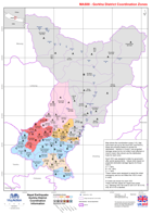
Map shows the coordination zones (1-6) that have been set up by the local DDC and NGO's, these are primarily based on access for distribution. Sectors A, B and C are projected damage...
Source: Nepal: Earthquake - Gorkha District - Coordination Information
Additional Information
| Field | Value |
|---|---|
| Data last updated | July 28, 2016 |
| Metadata last updated | July 28, 2016 |
| Created | July 28, 2016 |
| Format | PNG |
| License | License not specified |
| Has views | True |
| Id | bc21f72c-ac78-4af9-aa83-1410a4660459 |
| On same domain | True |
| Package id | 4f20c99c-e5a4-4eb9-b658-612484e28b5b |
| Position | 2 |
| Revision id | 7f65da78-919d-4e02-91ac-b1143691a83b |
| State | active |
| Url type | upload |