thumbnail.png
From the dataset abstract
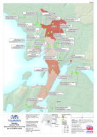
Map shows the number of location and status of evacation centres in Port Vila. The underlying damage building data shows the count of damaged buildings, but not the degree of the damage.
Source: Vanuatu: Cyclone PAM - Reported damage in Port Vila(as of 22 March 2015)
Additional Information
| Field | Value |
|---|---|
| Data last updated | July 28, 2016 |
| Metadata last updated | July 28, 2016 |
| Created | July 28, 2016 |
| Format | PNG |
| License | License not specified |
| Has views | True |
| Id | b4a4ff71-fc67-4166-bb4e-cb6689b6599e |
| On same domain | True |
| Package id | 90de4a1d-e06d-4dc6-85a6-c624db5eeb25 |
| Position | 2 |
| Revision id | c4caadd9-a468-4dd9-816a-c4f910e08924 |
| State | active |
| Url type | upload |