thumbnail.png
From the dataset abstract
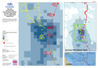
Map shows the 24 hourly accumulated rainfall total, the storm track of Cyclone Pam and its strength at specific times and locations.
Source: Vanuatu: Cyclone PAM - Accumulated Rainfall - 24 Hour Total (mm) (as of 14 Mar 2015 03:00 UTC)
Additional Information
| Field | Value |
|---|---|
| Data last updated | July 28, 2016 |
| Metadata last updated | July 28, 2016 |
| Created | July 28, 2016 |
| Format | PNG |
| License | License not specified |
| Has views | True |
| Id | 0dccaba2-ed7a-4d17-b1d4-08f2836a8c66 |
| On same domain | True |
| Package id | da0b51f6-7923-4bee-a96d-7036e8f1db52 |
| Position | 2 |
| Revision id | 4542568b-9248-42e7-9ae6-bbc1af1badeb |
| State | active |
| Url type | upload |