thumbnail.png
From the dataset abstract
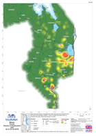
Map shows the density of displacement sites that have been reported since the start of the flooding in Malawi. It does not reflect the status (open or closed) of the sites merely the...
Source: Malawi: Floods-Density of displacement sites(as of 18 Feb 2015)
Additional Information
| Field | Value |
|---|---|
| Data last updated | July 4, 2016 |
| Metadata last updated | July 4, 2016 |
| Created | July 4, 2016 |
| Format | PNG |
| License | License not specified |
| Has views | True |
| Id | c9ae4632-670b-42e9-b093-028a08faa705 |
| On same domain | True |
| Package id | 2f1b1e58-ef61-4993-aa27-9c9d67482b00 |
| Position | 2 |
| Revision id | bca020a1-cfb3-47b2-a83d-2ec7e9096805 |
| State | active |
| Url type | upload |