thumbnail.png
From the dataset abstract
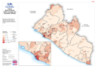
Map shows the Radio Stations in operation across the country, also displayed is population density by District so shows areas potentially not covered.
Source: Liberia: Ebola Outbreak - Radio Coverage and Population Density
Additional Information
| Field | Value |
|---|---|
| Data last updated | July 28, 2016 |
| Metadata last updated | July 28, 2016 |
| Created | July 28, 2016 |
| Format | PNG |
| License | License not specified |
| Has views | True |
| Id | 2e0b1449-ab79-4b57-97d8-222434aab07e |
| On same domain | True |
| Package id | d5ddf841-7b4e-4db4-b732-28de54b1cf78 |
| Position | 2 |
| Revision id | 29f6fead-628c-4893-86c4-cc0f9074caea |
| State | active |
| Url type | upload |