thumbnail.png
From the dataset abstract
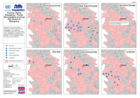
Distribution of key drivers of the emergency over the majority affected municipalities. Icons represent municipalities where drivers have been noted. Highlighted municipalities are all...
Additional Information
| Field | Value |
|---|---|
| Data last updated | July 28, 2016 |
| Metadata last updated | July 28, 2016 |
| Created | July 28, 2016 |
| Format | PNG |
| License | License not specified |
| Has views | True |
| Id | 98aa2b67-e110-4d53-8f55-be7761e4caf7 |
| On same domain | True |
| Package id | a2e61ac1-7059-4277-b51b-fb04484cedc1 |
| Position | 2 |
| Revision id | 214752a4-8a51-44e7-b091-009dbaa4f548 |
| State | active |
| Url type | upload |