thumbnail.png
From the dataset abstract
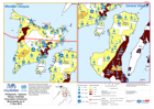
MA013c Map shows number of Evacuation Centres per municipality (top figure) and the population within each evacuation centre (lower figure) for Central and Western Visayas. Percentage of...
Source: Philippines - Typhoon Haiyan (Yolanda)Evacuation Centres by Municipality as of 11 Nov 2013
Additional Information
| Field | Value |
|---|---|
| Data last updated | July 28, 2016 |
| Metadata last updated | July 28, 2016 |
| Created | July 28, 2016 |
| Format | PNG |
| License | License not specified |
| Has views | True |
| Id | 83fdf31f-dfa2-4113-a7d0-b96cc4b357cf |
| On same domain | True |
| Package id | 04a59c15-2970-4224-9368-9cb21f5c2372 |
| Position | 2 |
| Revision id | 3ec99603-287d-4f56-a5b3-da5e3a3893f5 |
| State | active |
| Url type | upload |