thumbnail.png
From the dataset abstract
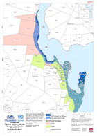
Map shows Tacloban City affected Barangays with extent of predicted and actual surge. Detail has been digitised from data from Taclobanand City Planning.
Source: Philippines Typhoon Haiyan (Yolanda) Tacloban City Affected Barangays (as of 23-Nov-2013)
Additional Information
| Field | Value |
|---|---|
| Data last updated | July 28, 2016 |
| Metadata last updated | July 28, 2016 |
| Created | July 28, 2016 |
| Format | PNG |
| License | License not specified |
| Has views | True |
| Id | 9ab1b57a-76be-40ee-8c00-3dfe410d5463 |
| On same domain | True |
| Package id | bfcdfd6a-7445-45f6-b9ec-9fd599f863c6 |
| Position | 1 |
| Revision id | a9a086e3-306a-4865-9806-a21d2c4b623b |
| State | active |
| Url type | upload |