thumbnail.png
From the dataset abstract
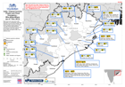
Map shows who-what-where (3W) information on humanitarian responses following Tropical Cyclone Phailin, and further flooding, during October 2013. The map shows relief assistance reported...
Source: India: Tropical Cyclone Phailin and Flood Emergency - Who-What-Where(as of 7 Nov 2013)
Additional Information
| Field | Value |
|---|---|
| Data last updated | July 28, 2016 |
| Metadata last updated | July 28, 2016 |
| Created | July 28, 2016 |
| Format | PNG |
| License | License not specified |
| Has views | True |
| Id | 42c5d84e-0807-4a13-bbfe-452951738d11 |
| On same domain | True |
| Package id | 40d140cf-767b-4076-8adb-d69b380f7bad |
| Position | 2 |
| Revision id | bde4c64d-ce08-401b-a7a9-080690d88706 |
| State | active |
| Url type | upload |