thumbnail.png
From the dataset abstract
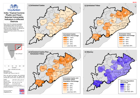
Map shows the selected population demographics taken from the 2011 census at block level, for the districts that have been identified as affected by Tropical Cyclone Phailin and...
Source: India: Tropical Cyclone Phailin and Flood -Selected Vulnerablity Indicators in Affected Districts
Additional Information
| Field | Value |
|---|---|
| Data last updated | July 28, 2016 |
| Metadata last updated | July 28, 2016 |
| Created | July 28, 2016 |
| Format | PNG |
| License | License not specified |
| Has views | True |
| Id | 38a83634-637e-48ee-8a22-7ef3aee4f285 |
| On same domain | True |
| Package id | ac0fe940-fe22-4438-aad9-24a087cfc178 |
| Position | 2 |
| Revision id | b7ce594d-4104-4cb6-bf01-0b16ba843159 |
| State | active |
| Url type | upload |