thumbnail.png
From the dataset abstract
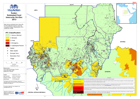
Map shows estimated food insecurity for flood affected regions using the Integrated Phase Classification (IPC) scale from FEWS
Additional Information
| Field | Value |
|---|---|
| Data last updated | July 28, 2016 |
| Metadata last updated | July 28, 2016 |
| Created | July 28, 2016 |
| Format | PNG |
| License | License not specified |
| Has views | True |
| Id | 59bc6157-6ffa-45c4-89c0-b875b495342c |
| On same domain | True |
| Package id | d29b5ec1-74a2-45ce-9097-8eb948a3a3cb |
| Position | 2 |
| Revision id | 0ffa230f-c147-434f-82b4-042061d00cbf |
| State | active |
| Url type | upload |