thumbnail.png
From the dataset abstract
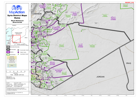
Map of Duma District in Rural Damascus Governorate, Syria, showing sub-district boundaries over basemap (includes District and Sub-District names in English and Arabic with P-Codes)
Source: Syria - District Maps: Duma District in Rural Damascus Governorate
Additional Information
| Field | Value |
|---|---|
| Data last updated | July 28, 2016 |
| Metadata last updated | July 28, 2016 |
| Created | July 28, 2016 |
| Format | PNG |
| License | License not specified |
| Has views | True |
| Id | 996b5632-2b12-48bf-84e9-7a1cd8cb59ed |
| On same domain | True |
| Package id | 15912f82-b841-4d23-a177-e38351759ebf |
| Position | 2 |
| Revision id | 393e620b-7a77-4afe-abc3-b37b481fe36b |
| State | active |
| Url type | upload |