thumbnail.png
From the dataset abstract
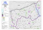
Map of Jarablus District in Aleppo Governorate, Syria, showing sub-district boundaries over basemap (includes District and Sub-District names in English and Arabic with P-Codes)
Source: Syria - District Maps: Jarablus District in Aleppo Governorate
Additional Information
| Field | Value |
|---|---|
| Data last updated | July 28, 2016 |
| Metadata last updated | July 28, 2016 |
| Created | July 28, 2016 |
| Format | PNG |
| License | License not specified |
| Has views | True |
| Id | 40c877b3-629b-4e04-bb9c-142bc028602e |
| On same domain | True |
| Package id | dc6742bc-ef75-4f06-ae4b-3eff8cb5413a |
| Position | 2 |
| Revision id | 93f6f558-148a-4e46-bbde-a93951a3cfb4 |
| State | active |
| Url type | upload |