thumbnail.png
From the dataset abstract
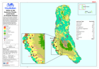
Land cover on Grande Comore. Showing affected villages. The data shown on this map were not created for the purposes of disaster response, and therefore should only be used as an...
Source: Union of the Comoros: Floods - Land Cover on Grande Comore
Additional Information
| Field | Value |
|---|---|
| Data last updated | July 28, 2016 |
| Metadata last updated | July 28, 2016 |
| Created | July 28, 2016 |
| Format | PNG |
| License | License not specified |
| Has views | True |
| Id | 53865d10-3675-4821-8897-71f958198f85 |
| On same domain | True |
| Package id | 6b335621-a506-42e0-aecb-6df87477ba97 |
| Position | 2 |
| Revision id | 03f4ae23-3ae2-492f-b2a0-736647244415 |
| State | active |
| Url type | upload |