thumbnail.png
From the dataset abstract
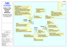
Map provides a geographic picture of which organisations, their location and the sectors that they are addressing are engaged in the humanitarina response to the flooding in the Comoros.
Additional Information
| Field | Value |
|---|---|
| Data last updated | July 28, 2016 |
| Metadata last updated | July 28, 2016 |
| Created | July 28, 2016 |
| Format | PNG |
| License | License not specified |
| Has views | True |
| Id | 7c92d659-3602-48d2-832e-46d58bb3513c |
| On same domain | True |
| Package id | 7253a3fe-508b-40a8-a821-6c3d645b5db7 |
| Position | 2 |
| Revision id | 4f0c3faa-8e59-43c0-9664-3b0b5ecd65d7 |
| State | active |
| Url type | upload |