thumbnail.png
From the dataset abstract
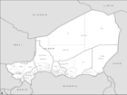
PowerPoint maps illustrating level 1 and level 2 administrative boundaries and transport links - click link to download - Sahel Crisis: PowerPoint Map Niger
Additional Information
| Field | Value |
|---|---|
| Data last updated | July 28, 2016 |
| Metadata last updated | July 28, 2016 |
| Created | July 28, 2016 |
| Format | PNG |
| License | License not specified |
| Has views | True |
| Id | ccdf25ca-632c-4d8f-8157-c661068f95c3 |
| On same domain | True |
| Package id | 67d91138-4b09-467d-9ace-fcf95342782a |
| Position | 3 |
| Revision id | 7c0b8071-271e-4dbf-9799-1174ceadb6ba |
| State | active |
| Url type | upload |