thumbnail.png
From the dataset abstract
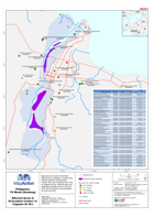
Map shows the extent of the flood affected area, indicative no build zones and the locations of Evacuation Centres (EC) and Transitory Sites (TS) in Cagayan de Oro. Affected area and...
Source: Philippines TS Washi (Sendong) Affected Areas & Evacuation Centers in Cagayan de Oro
Additional Information
| Field | Value |
|---|---|
| Data last updated | July 28, 2016 |
| Metadata last updated | July 28, 2016 |
| Created | July 28, 2016 |
| Format | PNG |
| License | License not specified |
| Has views | True |
| Id | 0446a088-b919-4b4e-adfd-28899c487cec |
| On same domain | True |
| Package id | 5a7d2c5f-607e-4c57-b3eb-696432c521c0 |
| Position | 2 |
| Revision id | bc6c20a4-10f0-41a9-9c3e-e6eb6a830510 |
| State | active |
| Url type | upload |