thumbnail.png
From the dataset abstract
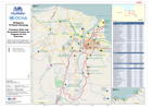
Map shows the city of Cagayan de Oro and the location of Evacuation Centres / Transitory Sites as at 20th January 2012
Source: Philippines TS Washi (Sendong) Transitory Sites and Evacuation Centres for Cagayan de Oro Overview
Additional Information
| Field | Value |
|---|---|
| Data last updated | July 28, 2016 |
| Metadata last updated | July 28, 2016 |
| Created | July 28, 2016 |
| Format | PNG |
| License | License not specified |
| Has views | True |
| Id | 0fabf401-de33-4f1d-97b5-b5839d4714b5 |
| On same domain | True |
| Package id | ba9936ec-93b8-473f-9e1c-33605ad533b8 |
| Position | 2 |
| Revision id | c25fb4f3-50ce-41cb-b86d-d36e940cc16d |
| State | active |
| Url type | upload |