thumbnail.png
From the dataset abstract
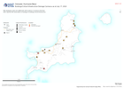
Map displaying roads and settlements with locations in Carriacou that have been reported with observations of damage to buildings/critical infrastructure.
Source: Buildings/Critical Infrastructure Damage Carriacou as at July 17, 2024
Additional Information
| Field | Value |
|---|---|
| Data last updated | July 17, 2024 |
| Metadata last updated | July 17, 2024 |
| Created | July 17, 2024 |
| Format | PNG |
| License | License not specified |
| Has views | True |
| Id | f962f1fd-cd1b-4e70-9cc9-ebff4fa40c88 |
| Mimetype | image/png |
| On same domain | True |
| Package id | 2d290173-161f-4cd4-8e74-76956f818d19 |
| Position | 2 |
| Revision id | 76f842dc-89b5-442d-b09f-d1feeab5e29e |
| Size | 9.6 KiB |
| State | active |
| Url type | upload |