thumbnail.png
From the dataset abstract
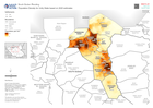
Example: Map shows the extent of known flooding from satellite images on 1 Jan 2012.
Source: Population Density for Unity State based on 2020 estimates
Additional Information
| Field | Value |
|---|---|
| Data last updated | October 31, 2022 |
| Metadata last updated | October 31, 2022 |
| Created | October 31, 2022 |
| Format | PNG |
| License | License not specified |
| Has views | True |
| Id | 84f30a29-b2ce-4e96-9325-99fdfcfe07ae |
| Mimetype | image/png |
| On same domain | True |
| Package id | e12ab0c6-f42d-44d9-9258-f8d584bc3bb6 |
| Position | 2 |
| Revision id | 389e7d09-a161-4e91-a810-458808501d12 |
| Size | 16.8 KiB |
| State | active |
| Url type | upload |