thumbnail.png
From the dataset abstract
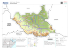
Country overview map showing main settlements, transport links, elevation, water features and administrative boundaries
Source: Country overview
Additional Information
| Field | Value |
|---|---|
| Data last updated | October 25, 2022 |
| Metadata last updated | October 25, 2022 |
| Created | October 25, 2022 |
| Format | PNG |
| License | License not specified |
| Has views | True |
| Id | 5de4b321-cf27-4dce-a515-e403e6647540 |
| Mimetype | image/png |
| On same domain | True |
| Package id | efda5037-dee4-430a-aa23-621b2dbd4f6d |
| Position | 2 |
| Revision id | e5dc1640-67d2-44f0-b6a6-50d2a764bef6 |
| Size | 17.1 KiB |
| State | active |
| Url type | upload |