thumbnail.png
From the dataset abstract
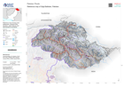
A reference map atlas of maps per Province showing the main settlements, transport links, elevation, water features and administrative boundaries
Additional Information
| Field | Value |
|---|---|
| Data last updated | September 6, 2022 |
| Metadata last updated | September 6, 2022 |
| Created | September 6, 2022 |
| Format | PNG |
| License | License not specified |
| Has views | True |
| Id | 06982691-7d6a-46f3-84fb-921a1d623401 |
| Mimetype | image/png |
| On same domain | True |
| Package id | 60d67221-c920-4b09-a33f-d5790eca9908 |
| Position | 7 |
| Revision id | 000e6f51-a814-4efa-8a98-45f6a25f8076 |
| Size | 16.7 KiB |
| State | active |
| Url type | upload |