thumbnail.png
From the dataset abstract
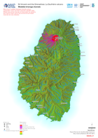
Map shows modelled drainage channels using a combination of 5m and 30m resolution elevation data. Whilst many of the channelsdo have water (i.e. streams and rivers) in them some may not...
Source: Modelled drainage channels
Additional Information
| Field | Value |
|---|---|
| Data last updated | May 7, 2021 |
| Metadata last updated | May 7, 2021 |
| Created | May 7, 2021 |
| Format | PNG |
| License | License not specified |
| Has views | True |
| Id | d43067c9-83ad-4a4f-b930-b51b9fac0554 |
| Mimetype | image/png |
| On same domain | True |
| Package id | 8196e385-dc72-4f73-9f73-f33d7fde78f5 |
| Position | 2 |
| Revision id | 0e61daae-bb12-4b4f-88bc-e0cf308f8029 |
| Size | 31.5 KiB |
| State | active |
| Url type | upload |