thumbnail.png
From the dataset abstract
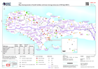
Map showing health facilities with level of damage in the departments of Grand'Anse, Nippes and Sud. Map based upon data published by PAHO accessed on 31/08/2021
Source: Map showing location of health facilities and known damage status (as of 03 Sept 2021)
Additional Information
| Field | Value |
|---|---|
| Data last updated | September 5, 2021 |
| Metadata last updated | September 5, 2021 |
| Created | September 5, 2021 |
| Format | PNG |
| License | License not specified |
| Has views | True |
| Id | db167fe1-1a12-443f-ae0d-20803c858f31 |
| Mimetype | image/png |
| On same domain | True |
| Package id | 15dce992-7e15-4f8c-9151-46ba801f9df1 |
| Position | 2 |
| Revision id | 6d0bbb2a-9adf-4efe-b090-96ea526a3139 |
| Size | 20.2 KiB |
| State | active |
| Url type | upload |