thumbnail.png
From the dataset abstract
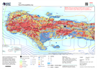
Hazard susceptibility map, showing flood zones and landslide susceptibility mapping, together with earthquake shake intensity information and rainfall isohyets from the last 7 days...
Source: Hazard Susceptibility map
Additional Information
| Field | Value |
|---|---|
| Data last updated | August 19, 2021 |
| Metadata last updated | August 19, 2021 |
| Created | August 19, 2021 |
| Format | PNG |
| License | Creative Commons Attribution |
| Has views | True |
| Id | 12f9ca5d-59c5-4d78-ae46-bd70a095f3d2 |
| Mimetype | image/png |
| On same domain | True |
| Package id | 24492467-74d9-4605-9957-77409fb6ddbf |
| Position | 2 |
| Revision id | 0243416a-6fea-4e18-b977-578f742d7df3 |
| Size | 29.5 KiB |
| State | active |
| Url type | upload |