thumbnail.png
From the dataset abstract
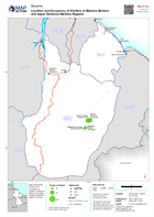
Map showing the location and occupancy of shelters in Mahaica Berbice and Upper Demerara-Berbice regions, Guyana
Source: Location and Occupancy of Shelters in Mahaica Berbice and Upper Demerara-Berbice Regions
Additional Information
| Field | Value |
|---|---|
| Data last updated | June 26, 2021 |
| Metadata last updated | June 26, 2021 |
| Created | June 26, 2021 |
| Format | PNG |
| License | License not specified |
| Has views | True |
| Id | fc901787-fbda-40a0-b7cc-a71302fdd400 |
| Mimetype | image/png |
| On same domain | True |
| Package id | 63997ecf-c717-437d-9cd2-ec6b0f929f56 |
| Position | 2 |
| Revision id | 519ff902-7d8e-4272-b96a-f0916f53e10a |
| Size | 22.5 KiB |
| State | active |
| Url type | upload |