thumbnail.png
From the dataset abstract
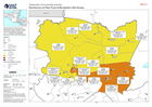
Map showing the food security classification (as of October 2020), as well as landslide threat (as of 16/11/2020) and population figures (2018) in each Municipality.
Source: Guatemala: Food Security and Flood Threat by Municipality in Alta Verapaz
Additional Information
| Field | Value |
|---|---|
| Data last updated | November 27, 2020 |
| Metadata last updated | November 27, 2020 |
| Created | November 27, 2020 |
| Format | PNG |
| License | License not specified |
| Has views | True |
| Id | 90904206-c90e-4e8d-9437-5c35dee18698 |
| Mimetype | image/png |
| On same domain | True |
| Package id | d2b20b09-fe7e-46ba-bce4-ad733d7704d8 |
| Position | 2 |
| Revision id | 4655ceac-020f-4f7d-9659-b26a9c061592 |
| Size | 19.8 KiB |
| State | active |
| Url type | upload |